IMAGES TAKEN NEAR TO
Stone Pit Lane, GRANTHAM, NG32 2JH
Introduction
This page details the photographs taken nearby to Stone Pit Lane, NG32 2JH by members of the Geograph project.
The Geograph project started in 2005 with the aim of publishing, organising and preserving representative images for every square kilometre of Great Britain, Ireland and the Isle of Man.

There are currently over 7.5m images from over14,400 individuals and you can help contribute to the project by visiting https://www.geograph.org.uk
Image Map
Images are licensed for reuse under creativecommons.org/licenses/by-sa/2.0
Notes
- Clicking on the map will re-center to the selected point.
- The higher the marker number, the further away the image location is from the centre of the postcode.
Image Listing (82 Images Found)
Images are licensed for reuse under creativecommons.org/licenses/by-sa/2.0
Image
Details
Distance
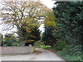
1
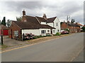
The Old Forge, Marston
On Stonepit Lane
Image: © Eirian Evans
Taken: 28 Jul 2022
0.01 miles
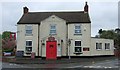
2
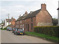
Mutilated cottages
Bear a datestone ICT 1849. ICT translates as John Charles Thorold, 11th Baronet of Marston (1816-1866).
Image: © Jonathan Thacker
Taken: 27 Apr 2014
0.01 miles

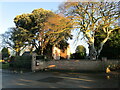
4
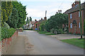
Stonepit Lane, Marston
The cottages in the centre of the photograph are just in Image
Image: © Kate Jewell
Taken: 6 Aug 2006
0.04 miles
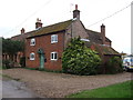

10
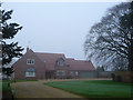
Westfield Lodge
The last house on way out of Marston along Stonepits Lane.
Image: © John Allan
Taken: 10 Jan 2013
0.08 miles