IMAGES TAKEN NEAR TO
Cliff Lane, GRANTHAM, NG32 2HU
Introduction
This page details the photographs taken nearby to Cliff Lane, NG32 2HU by members of the Geograph project.
The Geograph project started in 2005 with the aim of publishing, organising and preserving representative images for every square kilometre of Great Britain, Ireland and the Isle of Man.

There are currently over 7.5m images from over14,400 individuals and you can help contribute to the project by visiting https://www.geograph.org.uk
Image Map
Images are licensed for reuse under creativecommons.org/licenses/by-sa/2.0
Notes
- Clicking on the map will re-center to the selected point.
- The higher the marker number, the further away the image location is from the centre of the postcode.
Image Listing (6 Images Found)
Images are licensed for reuse under creativecommons.org/licenses/by-sa/2.0
Image
Details
Distance
1
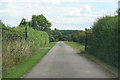
Entrance to Cliff Farm
Jericho Wood on the horizon, Image
Image: © Kate Jewell
Taken: 6 Aug 2006
0.02 miles
2
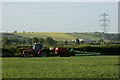
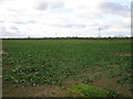
Spraying herbicide on winter wheat
Looking south from Cliff Lane. The ridge in the background is at Great Gonerby.
Image: © Simon Mortimer
Taken: 2 May 2011
0.15 miles
3
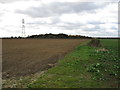
Field edge and Bees' Gorse
Seen from Cliff Lane.
Image: © Jonathan Thacker
Taken: 5 Nov 2016
0.16 miles
5
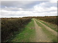
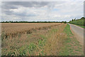
Cliff Lane
South of the turn to Cliff Farm Cliff Lane is only a track.
Image: © Jonathan Thacker
Taken: 5 Nov 2016
0.21 miles
6
Field of oilseed rape off Cliff Lane
Image: © Jonathan Thacker
Taken: 5 Nov 2016
0.22 miles