IMAGES TAKEN NEAR TO
School Lane, GRANTHAM, NG32 2HQ
Introduction
This page details the photographs taken nearby to School Lane, NG32 2HQ by members of the Geograph project.
The Geograph project started in 2005 with the aim of publishing, organising and preserving representative images for every square kilometre of Great Britain, Ireland and the Isle of Man.

There are currently over 7.5m images from over14,400 individuals and you can help contribute to the project by visiting https://www.geograph.org.uk
Image Map
Images are licensed for reuse under creativecommons.org/licenses/by-sa/2.0
Notes
- Clicking on the map will re-center to the selected point.
- The higher the marker number, the further away the image location is from the centre of the postcode.
Image Listing (79 Images Found)
Images are licensed for reuse under creativecommons.org/licenses/by-sa/2.0
Image
Details
Distance
1
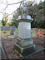
Memorial to Thomas Brown, Marston churchyard
Image: © Jonathan Thacker
Taken: 12 Dec 2021
0.03 miles
2
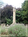
Sundial, Church of St Mary
A column surmounted by a triangular block of 3 sided sundial in the church yard of St Mary, Marston. It is listed Grade II
Image: © Eirian Evans
Taken: 28 Jul 2022
0.03 miles
3
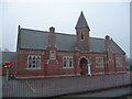
Marston Thorold's Charity Church of England Primary School
Image: © John Allan
Taken: 10 Jan 2013
0.03 miles
4
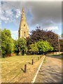
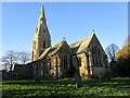
St Mary's Church, Marston
The broach spire of St. Mary’s Church is a prominent landmark across the River Witham, from the railway to the east and the A1 to the west. These broach spires, where the spire grows out of the tower without a parapet or pinnacles and is supported only by its broaches at the four corners, were the earliest spires to be built (13th century). The Church itself is of distinctive architectural and monumental interest and is grade I-listed by English Heritage (English Heritage Building ID: 193966 http://www.britishlistedbuildings.co.uk/en-193966-church-of-st-mary-marston-lincolnshire British Listed Buildings). The church is of 12th-century origin, with an 1881-82 chancel restored and partly rebuilt in Early English style.
http://parishes.lincolnshire.gov.uk/marston/section.asp?catId=13125 Marston Parish Council
Image: © David Dixon
Taken: 4 Aug 2014
0.03 miles
5
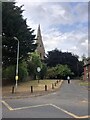
Lane to St Mary's Church
The village sign is on the green on the left
Image: © Eirian Evans
Taken: 28 Jul 2022
0.04 miles
7
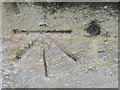
Ordnance Survey Cut Mark with Bolt
This can be found on the wall of St Mary's Church.
For more detail see : http://www.bench-marks.org.uk/bm25088
Image: © Peter Wood
Taken: 26 Sep 2012
0.04 miles
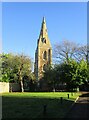
8
Marston: St. Mary's Church with its heavy broach spire
Image: © Michael Garlick
Taken: 18 Sep 2016
0.04 miles
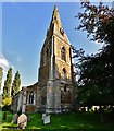
9
St. Mary's church, Marston
A medieval church of many periods though the chnacel is of 1881-2 https://historicengland.org.uk/listing/the-list/list-entry/1146946?section=official-listing
Image: © Jonathan Thacker
Taken: 12 Dec 2021
0.04 miles
10
Village Green and St. Mary's church, Marston
Image: © Jonathan Thacker
Taken: 12 Dec 2021
0.04 miles