IMAGES TAKEN NEAR TO
Barrowby Stenwith, GRANTHAM, NG32 2HE
Introduction
This page details the photographs taken nearby to NG32 2HE by members of the Geograph project.
The Geograph project started in 2005 with the aim of publishing, organising and preserving representative images for every square kilometre of Great Britain, Ireland and the Isle of Man.

There are currently over 7.5m images from over14,400 individuals and you can help contribute to the project by visiting https://www.geograph.org.uk
Image Map
Images are licensed for reuse under creativecommons.org/licenses/by-sa/2.0
Notes
- Clicking on the map will re-center to the selected point.
- The higher the marker number, the further away the image location is from the centre of the postcode.
Image Listing (53 Images Found)
Images are licensed for reuse under creativecommons.org/licenses/by-sa/2.0
Image
Details
Distance
1
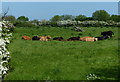
Cattle in a field next to the River Devon
Image: © Mat Fascione
Taken: 17 May 2014
0.05 miles

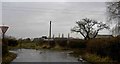
4
River Devon at Stenwith
Viewed from the Woolsthorpe Lane bridge.
Image: © Mat Fascione
Taken: 17 May 2014
0.08 miles
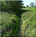
10
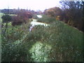
Grantham Canal not in use
This view from Stenwith bridge is looking northwest along the Grantham Canal. The thick vegetation is perfect habitat for reed-buntings and other species but canal traffic will need this lot cleared -- if the canal is to be working again; so we have a conflict of interest.
Image: © Brian Green
Taken: 17 Nov 2006
0.14 miles