IMAGES TAKEN NEAR TO
Sedgebrook, GRANTHAM, NG32 2HD
Introduction
This page details the photographs taken nearby to NG32 2HD by members of the Geograph project.
The Geograph project started in 2005 with the aim of publishing, organising and preserving representative images for every square kilometre of Great Britain, Ireland and the Isle of Man.

There are currently over 7.5m images from over14,400 individuals and you can help contribute to the project by visiting https://www.geograph.org.uk
Image Map
Images are licensed for reuse under creativecommons.org/licenses/by-sa/2.0
Notes
- Clicking on the map will re-center to the selected point.
- The higher the marker number, the further away the image location is from the centre of the postcode.
Image Listing (8 Images Found)
Images are licensed for reuse under creativecommons.org/licenses/by-sa/2.0
Image
Details
Distance
1
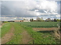
Breeder Hills Farm
Seen from Sewstern Lane.
Image: © Jonathan Thacker
Taken: 10 Apr 2012
0.05 miles
2
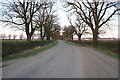
Woolsthorpe Lane
Near Stenwith and Muston with the Casthorpe Hills (Image) in the distance.
Image: © Kate Jewell
Taken: 16 Apr 2006
0.12 miles
3
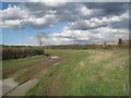
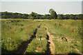
Sewstern Lane (3)
A former drove road now part of the Viking Way. Much concern has been expressed recently about the condition of Sewstern Lane particularly to the south of Woolsthorpe. There, as here, the surface is being heavily rutted from use by off-road vehicles and plant life damaged or even destroyed.
Breeder Hills Farm can be seen in the background.
Image: © Jonathan Thacker
Taken: 10 Apr 2012
0.14 miles
4
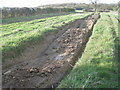
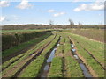
Sewstern Lane (5) deep rut
Off road vehicles are damaging the surface of Sewstern Lane and this is causing much concern locally. This rut is an extreme example of the damage that can be done. The wheel rut is over two feet deep.
Image: © Jonathan Thacker
Taken: 10 Apr 2012
0.15 miles
5
Sewstern Lane
Deeply rutted ancient drove road, made treacherous on a bicycle by off-road vehicles
Image: © Richard Croft
Taken: 9 Jul 2013
0.17 miles
6
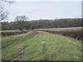
The Viking Way Looking Northwards
Image: © William Fairbrother
Taken: 20 Feb 2015
0.18 miles
7
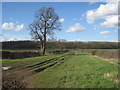
Sewstern Lane (2)
A former drove road now part of the Viking Way. Much concern has been expressed recently about the condition of Sewstern Lane particularly to the south of Woolsthorpe. There, as here, the surface is being heavily rutted from use by off-road vehicles and plant life damaged or even destroyed.
Image: © Jonathan Thacker
Taken: 10 Apr 2012
0.19 miles
8
Sewstern Lane (4)
A former drove road now part of the Viking Way. Much concern has been expressed recently about the condition of Sewstern Lane particularly to the south of Woolsthorpe. There, as here, the surface is being heavily rutted from use by off-road vehicles and plant life damaged or even destroyed.
Image: © Jonathan Thacker
Taken: 10 Apr 2012
0.21 miles