IMAGES TAKEN NEAR TO
Gonerby Lane, GRANTHAM, NG32 2DU
Introduction
This page details the photographs taken nearby to Gonerby Lane, NG32 2DU by members of the Geograph project.
The Geograph project started in 2005 with the aim of publishing, organising and preserving representative images for every square kilometre of Great Britain, Ireland and the Isle of Man.

There are currently over 7.5m images from over14,400 individuals and you can help contribute to the project by visiting https://www.geograph.org.uk
Image Map
Images are licensed for reuse under creativecommons.org/licenses/by-sa/2.0
Notes
- Clicking on the map will re-center to the selected point.
- The higher the marker number, the further away the image location is from the centre of the postcode.
Image Listing (42 Images Found)
Images are licensed for reuse under creativecommons.org/licenses/by-sa/2.0
Image
Details
Distance
2
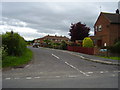
Lambert Road, Allington
Modern housing on the course of a much older track and pathway.
Image: © Anthony Vosper
Taken: 9 Jun 2012
0.03 miles
4
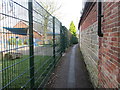
Path by the school
Links Side Street with Marston Lane.
Image: © Jonathan Thacker
Taken: 28 Mar 2016
0.06 miles
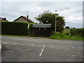
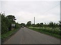
6
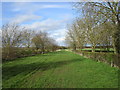
Marston Lane
Wide, and today, wet.
Image: © Jonathan Thacker
Taken: 28 Mar 2016
0.11 miles
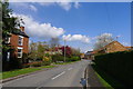
7
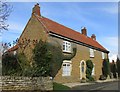
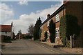
Stone built house, Side Street
The roof line has been changed at some time and brick used to fill the gap. I suspect that the concrete has been applied to the upper front wall to disguise the brick and give a slightly more uniform appearance.
Image: © Jonathan Thacker
Taken: 28 Mar 2016
0.13 miles