IMAGES TAKEN NEAR TO
Syston Park, GRANTHAM, NG32 2DA
Introduction
This page details the photographs taken nearby to NG32 2DA by members of the Geograph project.
The Geograph project started in 2005 with the aim of publishing, organising and preserving representative images for every square kilometre of Great Britain, Ireland and the Isle of Man.

There are currently over 7.5m images from over14,400 individuals and you can help contribute to the project by visiting https://www.geograph.org.uk
Image Map
Images are licensed for reuse under creativecommons.org/licenses/by-sa/2.0
Notes
- Clicking on the map will re-center to the selected point.
- The higher the marker number, the further away the image location is from the centre of the postcode.
Image Listing (13 Images Found)
Images are licensed for reuse under creativecommons.org/licenses/by-sa/2.0
Image
Details
Distance
1
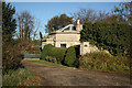
East Lodge
Lodge to the demolished Syston Park
Image: © Richard Croft
Taken: 13 Nov 2010
0.00 miles
2
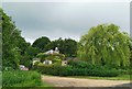
East Lodge, with topiary
Lodge to the demolished Syston Park - is it a sausage dog?
Image: © Chris Morgan
Taken: 19 Jun 2019
0.00 miles
3
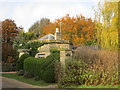
East Lodge, Syston Park
Dates from about 1830 https://historicengland.org.uk/listing/the-list/list-entry/1308688
Image: © Jonathan Thacker
Taken: 3 Nov 2019
0.01 miles
4
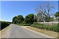
Heath Lane passing East Lodge
The lodge was once part of the former Syston Park estate
Image: © Tim Heaton
Taken: 13 Jul 2022
0.02 miles
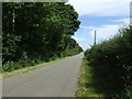
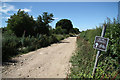
7
Heath Lane, an unclassified county road
Heading west.
Image: © J.Hannan-Briggs
Taken: 23 Mar 2014
0.20 miles
9
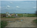
RAF Barkston Heath Crash Gate
This is one of seven crash gates situated around the airfield. These gates are used by the MOD Fire Service, mainly to exit the airfield in the event of a plane crash taking place off the main site.
Image: © Billy-Death
Taken: 9 Apr 2010
0.21 miles
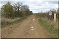
10
Heath Lane
National Byway over Barkston Heath
Image: © Richard Croft
Taken: 19 Jul 2010
0.22 miles