IMAGES TAKEN NEAR TO
Syston, GRANTHAM, NG32 2BX
Introduction
This page details the photographs taken nearby to NG32 2BX by members of the Geograph project.
The Geograph project started in 2005 with the aim of publishing, organising and preserving representative images for every square kilometre of Great Britain, Ireland and the Isle of Man.

There are currently over 7.5m images from over14,400 individuals and you can help contribute to the project by visiting https://www.geograph.org.uk
Image Map
Images are licensed for reuse under creativecommons.org/licenses/by-sa/2.0
Notes
- Clicking on the map will re-center to the selected point.
- The higher the marker number, the further away the image location is from the centre of the postcode.
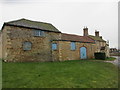
Image Listing (77 Images Found)
Images are licensed for reuse under creativecommons.org/licenses/by-sa/2.0
Image
Details
Distance

3
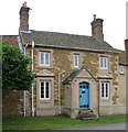
Syston - house on Main Street to north of Old Hall
Image: © Dave Bevis
Taken: 26 Jul 2012
0.01 miles
4
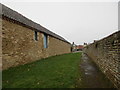
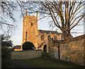
Footpath from the church to Main Street, Syston
Image: © Jonathan Thacker
Taken: 8 Feb 2018
0.02 miles
5
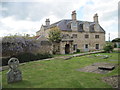
Syston Old Hall from the churchyard
Rebuilt in 1830 keeping a late 16th century porch
Image: © Martin Dawes
Taken: 15 Jun 2013
0.02 miles