IMAGES TAKEN NEAR TO
Palmer Road, GRANTHAM, NG32 2BW
Introduction
This page details the photographs taken nearby to Palmer Road, NG32 2BW by members of the Geograph project.
The Geograph project started in 2005 with the aim of publishing, organising and preserving representative images for every square kilometre of Great Britain, Ireland and the Isle of Man.

There are currently over 7.5m images from over14,400 individuals and you can help contribute to the project by visiting https://www.geograph.org.uk
Image Map
Images are licensed for reuse under creativecommons.org/licenses/by-sa/2.0
Notes
- Clicking on the map will re-center to the selected point.
- The higher the marker number, the further away the image location is from the centre of the postcode.
Image Listing (32 Images Found)
Images are licensed for reuse under creativecommons.org/licenses/by-sa/2.0
Image
Details
Distance
2

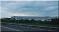
Brakes & Downtown
Brakes Food service & Downtown superstore.
Situated North of Grantham on the A1 Allington junction.
Viewed from Barrowby Thorns.
Image: © Richard Bamford
Taken: 27 Jun 2020
0.07 miles
4
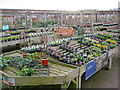
Plant display at Downtown Garden Centre
Huge area to accommodate pots outside at the back of the main building. Just visible above the covered walkway on the right is the rounded hill of Belton Gorse.
Image: © Trevor Rickard
Taken: 26 Nov 2011
0.13 miles
5
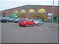
Downtown Garden Centre
Part of a huge shopping complex just off the A1. The entrance is on the right and the two-storey building must house one of the largest garden centres in the country. The four semi-circular windows at this end provide views over the car park for those in the cafe.
Image: © Trevor Rickard
Taken: 26 Nov 2011
0.13 miles
6
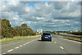
A1 northbound, Gonerby Moor
Here the road veers away to the left onto a new alignment avoiding a roundabout.
Image: © Robin Webster
Taken: 7 Oct 2011
0.14 miles
7
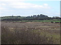
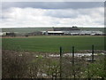
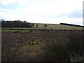
Belton Gorse and Hook Cliff
View from Occupation Road towards Belton Gorse (on the left with the pylon and aerial) and Hook Cliff on the right, with its nicely rounded tree-spattered top.
Image: © Ian Paterson
Taken: 21 Mar 2010
0.14 miles
8
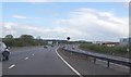
A1 approaching Services at Great Gonerby
Image: © Julian P Guffogg
Taken: 4 May 2013
0.14 miles
9
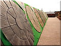
Paving Display at Downtown Garden centre
Interesting display of paved focal points at the Downtown Garden Centre. http://www.oldrids.co.uk/en-gb/store-finder/branch/?storeid=222
Image: © Ian Paterson
Taken: 21 Mar 2010
0.15 miles
10
Knox Plantation and Barrowby Thorns
View of two small woodland areas on the side of Newark Hill west of Great Gonerby. Knox plantation is on the left. See Image for a close up of one of the trees.
Image: © Ian Paterson
Taken: 21 Mar 2010
0.15 miles