IMAGES TAKEN NEAR TO
Barkston, GRANTHAM, NG32 2BT
Introduction
This page details the photographs taken nearby to NG32 2BT by members of the Geograph project.
The Geograph project started in 2005 with the aim of publishing, organising and preserving representative images for every square kilometre of Great Britain, Ireland and the Isle of Man.

There are currently over 7.5m images from over14,400 individuals and you can help contribute to the project by visiting https://www.geograph.org.uk
Image Map
Images are licensed for reuse under creativecommons.org/licenses/by-sa/2.0
Notes
- Clicking on the map will re-center to the selected point.
- The higher the marker number, the further away the image location is from the centre of the postcode.
Image Listing (5 Images Found)
Images are licensed for reuse under creativecommons.org/licenses/by-sa/2.0
Image
Details
Distance
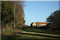
1
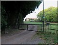
Track to Heath Farm
The building that is visible is not named on the map. Heath Farm is out of sight to the left.
Image: © Andrew Tatlow
Taken: 27 Sep 2011
0.17 miles
2
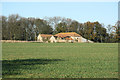
Heath Farm
Redundant farm buildings at Heath Farm
Image: © Richard Croft
Taken: 13 Nov 2010
0.18 miles
3
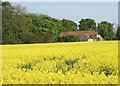
Heath Farm from Heath Lane
Looking north from Heath Lane across a field of oil seed rape.
Image: © Simon Mortimer
Taken: 30 Apr 2011
0.18 miles
4
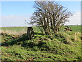
Looking north-east across Honington Heath
Triangulation Pillar and bush in the foreground.
Image: © Peter Wood
Taken: 4 Mar 2014
0.19 miles
5
Heath Farm
View to Heath Farm from the top of Minnett's Hill
Image: © Richard Croft
Taken: 13 Nov 2010
0.19 miles