IMAGES TAKEN NEAR TO
High Dyke, GRANTHAM, NG32 2BS
Introduction
This page details the photographs taken nearby to High Dyke, NG32 2BS by members of the Geograph project.
The Geograph project started in 2005 with the aim of publishing, organising and preserving representative images for every square kilometre of Great Britain, Ireland and the Isle of Man.

There are currently over 7.5m images from over14,400 individuals and you can help contribute to the project by visiting https://www.geograph.org.uk
Image Map
Images are licensed for reuse under creativecommons.org/licenses/by-sa/2.0
Notes
- Clicking on the map will re-center to the selected point.
- The higher the marker number, the further away the image location is from the centre of the postcode.
Image Listing (6 Images Found)
Images are licensed for reuse under creativecommons.org/licenses/by-sa/2.0
Image
Details
Distance
1
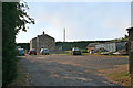
Pyewipe Cottages
On Ermine Street: the only buildings in this square.
Image: © Kate Jewell
Taken: 25 Jul 2006
0.06 miles
2
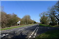
Road from Welby joining Ermine Street
The Roman road, a.k.a. 'High Dike' or the B6403, heading straight north to Ancaster
Image: © Tim Heaton
Taken: 18 Mar 2022
0.06 miles
3
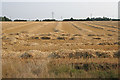
Harvested field
On Welby Lane: waiting for the baler.
Image: © Kate Jewell
Taken: 25 Jul 2006
0.09 miles
5
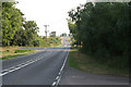
B6403 looking towards Colsterworth
Ermine Street, the Roman road from London to York, is also called High Dyke along this stretch.
Image: © Kate Jewell
Taken: 25 Jul 2006
0.21 miles
6
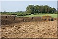
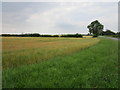
Sugar beet clamp near Welby
A storage clamp for last year's sugar beet, almost empty, in the corner of a field now planted with winter wheat.
Image: © Simon Mortimer
Taken: 30 Apr 2011
0.24 miles