IMAGES TAKEN NEAR TO
Brandon, GRANTHAM, NG32 2AY
Introduction
This page details the photographs taken nearby to NG32 2AY by members of the Geograph project.
The Geograph project started in 2005 with the aim of publishing, organising and preserving representative images for every square kilometre of Great Britain, Ireland and the Isle of Man.

There are currently over 7.5m images from over14,400 individuals and you can help contribute to the project by visiting https://www.geograph.org.uk
Image Map
Images are licensed for reuse under creativecommons.org/licenses/by-sa/2.0
Notes
- Clicking on the map will re-center to the selected point.
- The higher the marker number, the further away the image location is from the centre of the postcode.
Image Listing (8 Images Found)
Images are licensed for reuse under creativecommons.org/licenses/by-sa/2.0
Image
Details
Distance
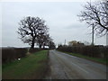
2
View towards woodland near Court Leys
Image: © Jonathan Thacker
Taken: 6 Jun 2012
0.12 miles
4
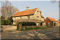
Court Leys Farm
Grade II listed 17th and 19th century farmhouse on Stragglethorpe Lane
Image: © Richard Croft
Taken: 9 Apr 2015
0.16 miles
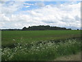
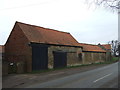
5
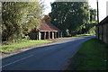
Open barn at Court Leys Farm
Looking along Stragglethorpe Lane towards Brandon.
Image: © Kate Jewell
Taken: 9 Oct 2006
0.18 miles
6
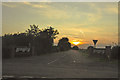
Sundown over the PFi Kart Racing Circuit - Caythorpe
Image: © Mick Lobb
Taken: 18 Aug 2009
0.23 miles
7
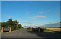
Entrance to PFI kart circuit from Stragglethorpe Lane
Image: © Steve Fareham
Taken: 11 Sep 2012
0.23 miles
8
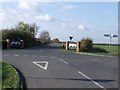
Junction of Gorse Hill Lane and Stragglethorpe Road
Entrance to PFI Kart racing circuit opposite.
Image: © J.Hannan-Briggs
Taken: 6 Nov 2011
0.24 miles