IMAGES TAKEN NEAR TO
Brandon Road, GRANTHAM, NG32 2AF
Introduction
This page details the photographs taken nearby to Brandon Road, NG32 2AF by members of the Geograph project.
The Geograph project started in 2005 with the aim of publishing, organising and preserving representative images for every square kilometre of Great Britain, Ireland and the Isle of Man.

There are currently over 7.5m images from over14,400 individuals and you can help contribute to the project by visiting https://www.geograph.org.uk
Image Map
Images are licensed for reuse under creativecommons.org/licenses/by-sa/2.0
Notes
- Clicking on the map will re-center to the selected point.
- The higher the marker number, the further away the image location is from the centre of the postcode.
Image Listing (7 Images Found)
Images are licensed for reuse under creativecommons.org/licenses/by-sa/2.0
Image
Details
Distance
1
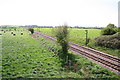
Mainline
Looking south-east from Hougham bridge
Image: © Richard Croft
Taken: 5 May 2006
0.19 miles
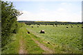
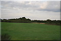
3
Grange Farm
Looking north towards Grange Farm
Image: © Richard Croft
Taken: 5 May 2006
0.21 miles
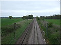
4
Towards Summerfield's Hill
Looking south-east towards Summerfield's Hill on the horizon, not much of a hill at 92m above sea level.
Image: © Richard Croft
Taken: 5 May 2006
0.21 miles
6
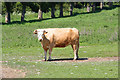
Longhorn
A longhorn steer at Grange Farm
Image: © Richard Croft
Taken: 3 Jun 2010
0.22 miles
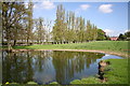
7
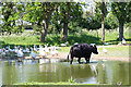
Grange Farm pond
Geese and a longhorn cow in the pond at Grange Farm
Image: © Richard Croft
Taken: 3 Jun 2010
0.22 miles