IMAGES TAKEN NEAR TO
Belvoir Road, GRANTHAM, NG32 1SN
Introduction
This page details the photographs taken nearby to Belvoir Road, NG32 1SN by members of the Geograph project.
The Geograph project started in 2005 with the aim of publishing, organising and preserving representative images for every square kilometre of Great Britain, Ireland and the Isle of Man.

There are currently over 7.5m images from over14,400 individuals and you can help contribute to the project by visiting https://www.geograph.org.uk
Image Map
Images are licensed for reuse under creativecommons.org/licenses/by-sa/2.0
Notes
- Clicking on the map will re-center to the selected point.
- The higher the marker number, the further away the image location is from the centre of the postcode.
Image Listing (11 Images Found)
Images are licensed for reuse under creativecommons.org/licenses/by-sa/2.0
Image
Details
Distance
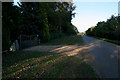
1
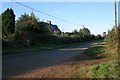
Belvoir Road
High Leas Farm behind the trees.
Image: © Kate Jewell
Taken: 21 Oct 2007
0.01 miles

4
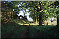
Farm track at High Leas Farm
Lings Hill in Image is in the distance.
Image: © Kate Jewell
Taken: 21 Oct 2007
0.08 miles
5

Oilseed rape crop towards woodland
Off Belvoir Road.
Image: © JThomas
Taken: 21 Jun 2014
0.12 miles
6
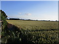
Wheat field near Eaton
On land once quarried for ironstone.
Image: © Jonathan Thacker
Taken: 20 Jul 2019
0.13 miles
7
Belvoir Road
. . . or otherwise known as the top road.
Image: © Kate Jewell
Taken: 21 Oct 2007
0.13 miles

9

Belvoir Road
Heading north east on loose chippings.
Image: © JThomas
Taken: 21 Jun 2014
0.14 miles
10
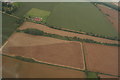
Field cultivation patterns NNW of Eaton: aerial 2020
Image: © Chris
Taken: 30 Aug 2020
0.16 miles