IMAGES TAKEN NEAR TO
Main Street, GRANTHAM, NG32 1SD
Introduction
This page details the photographs taken nearby to Main Street, NG32 1SD by members of the Geograph project.
The Geograph project started in 2005 with the aim of publishing, organising and preserving representative images for every square kilometre of Great Britain, Ireland and the Isle of Man.

There are currently over 7.5m images from over14,400 individuals and you can help contribute to the project by visiting https://www.geograph.org.uk
Image Map
Images are licensed for reuse under creativecommons.org/licenses/by-sa/2.0
Notes
- Clicking on the map will re-center to the selected point.
- The higher the marker number, the further away the image location is from the centre of the postcode.
Image Listing (172 Images Found)
Images are licensed for reuse under creativecommons.org/licenses/by-sa/2.0
Image
Details
Distance
1
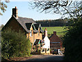
Main Street, Eaton
This cottage is in the featured square, the other two are in Image There is an annual hanging basket "competition" between this cottage and the brick one. The display is looking a bit tired after several very cold nights.
Image: © Kate Jewell
Taken: 21 Oct 2007
0.01 miles
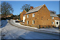
2
Cottages on Main Street, Eaton
In the low winter sunlight some streets in Eaton can be in shade nearly all day. This part of Main Street is particularly prone to ice as the sun never reaches it in late December and early January.
The first cottage is just in the featured square, the second and third being in SK8029.
Image: © Kate Jewell
Taken: 3 Jan 2010
0.01 miles
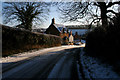
3
Stone cottage on Main Street
This cottage and the cream painted one behind are just in the featured square. The next one up the hill is in SK7929. See Image for the opposing view.
Image: © Kate Jewell
Taken: 3 Jan 2010
0.02 miles
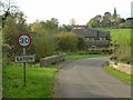
4
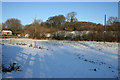
Small paddock, Eaton
Adjacent to Main Street just where it turns into Branston Lane. The ground rises from 96 to 115 metres beyond the paddock..
Image: © Kate Jewell
Taken: 3 Jan 2010
0.03 miles
6
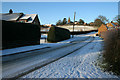
Main Street, Eaton
This is the lowest part of Eaton at 96 metres above sea level. The church, on the horizon, stands on the highest point at 130 metres. The modern house on the left used to be a coal merchant until he retired. Previous to that there was a terrace of tiny stone workers cottages on the site, which can be seen on the OS 1940s map.
Image: © Kate Jewell
Taken: 3 Jan 2010
0.05 miles


10
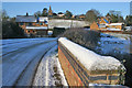
The entrance to Eaton on Branston Road
The bridge crosses the River Devon.
There is a bench mark http://www.geograph.org.uk/photo/5180333 on this end of the left hand parapet.
Image: © Alan Murray-Rust
Taken: 31 Oct 2016
0.07 miles