IMAGES TAKEN NEAR TO
Saltby Road, GRANTHAM, NG32 1QG
Introduction
This page details the photographs taken nearby to Saltby Road, NG32 1QG by members of the Geograph project.
The Geograph project started in 2005 with the aim of publishing, organising and preserving representative images for every square kilometre of Great Britain, Ireland and the Isle of Man.

There are currently over 7.5m images from over14,400 individuals and you can help contribute to the project by visiting https://www.geograph.org.uk
Image Map
Images are licensed for reuse under creativecommons.org/licenses/by-sa/2.0
Notes
- Clicking on the map will re-center to the selected point.
- The higher the marker number, the further away the image location is from the centre of the postcode.
Image Listing (87 Images Found)
Images are licensed for reuse under creativecommons.org/licenses/by-sa/2.0
Image
Details
Distance
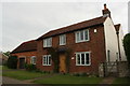
1
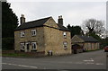
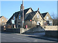
'The Old Forge' at the junction of the A607 and Saltby Road
There is an OS benchmark Image on the front of the house at its left hand corner
Image: © phil Richards
Taken: 7 May 2019
0.02 miles
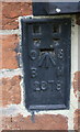
2
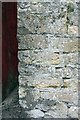
Benchmark on 'The Old Forge'
Ordnance Survey cut mark benchmark described on the Bench Mark Database at www.bench-marks.org.uk/bm80690
Image: © phil Richards
Taken: 7 May 2019
0.03 miles
3
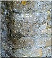
Bench mark, The Old Forge, Croxton Kerrial
See http://www.geograph.org.uk/photo/5194307 for location.
Image: © Alan Murray-Rust
Taken: 13 Nov 2016
0.03 miles
4
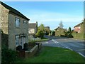
Main Street, Croxton Kerrial
There is a bench mark http://www.geograph.org.uk/photo/5194304 on the house on the left.
Image: © Alan Murray-Rust
Taken: 13 Nov 2016
0.04 miles
5
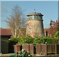
Lookout tower, Croxton Kerrial
The former windmill has been converted into a private house with its fine viewing room in place of the cap. When listed in 1990, the interior was largely stripped and the mill derelict. It is the only known example of a smock-mill tower in the county. Listed Grade II.
Image: © Alan Murray-Rust
Taken: 7 Nov 2016
0.05 miles
6
Six Top Road
There is an OS benchmark Image on the front of the cottage
Image: © phil Richards
Taken: 7 May 2019
0.06 miles
7
Benchmark on #6 Top Road
Ordnance Survey flush bracket (serial number 2078) described on the Bench Mark Database at www.bench-marks.org.uk/bm1894
Image: © phil Richards
Taken: 7 May 2019
0.06 miles
8
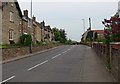
Main Street in Croxton Kerrial, Leicestershire
Image: © Mat Fascione
Taken: 10 May 2008
0.07 miles
9
Village post office and stores, Croxton Kerrial
This village is lucky, it still has its shop.
View from the junction of Middle Road with Main Street: the main A607 Melton Mowbray to Grantham road.
Image: © Kate Jewell
Taken: 30 Jan 2010
0.09 miles
10
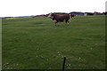
Bulls in field on west side of Saltby Road
Image: © Roger Templeman
Taken: 7 May 2019
0.10 miles