IMAGES TAKEN NEAR TO
Harston, GRANTHAM, NG32 1PL
Introduction
This page details the photographs taken nearby to NG32 1PL by members of the Geograph project.
The Geograph project started in 2005 with the aim of publishing, organising and preserving representative images for every square kilometre of Great Britain, Ireland and the Isle of Man.

There are currently over 7.5m images from over14,400 individuals and you can help contribute to the project by visiting https://www.geograph.org.uk
Image Map
Images are licensed for reuse under creativecommons.org/licenses/by-sa/2.0
Notes
- Clicking on the map will re-center to the selected point.
- The higher the marker number, the further away the image location is from the centre of the postcode.
Image Listing (34 Images Found)
Images are licensed for reuse under creativecommons.org/licenses/by-sa/2.0
Image
Details
Distance
1
New Cottages
Now a set of isolated rural cottages, these would have been at the centre of a hive of activity during the first part of the 20th century when this was a major ironstone quarrying area. They were built by the quarry company for its workers.
Image: © Alan Murray-Rust
Taken: 21 Aug 2013
0.01 miles
2
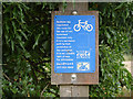
Sustrans notice
At the start of the route along the trackbed of the old Great Northern Railway Denton Branch which served the Woolsthorpe Ironstone Quarries.
Image: © Alan Murray-Rust
Taken: 21 Aug 2013
0.03 miles
3
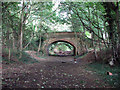
Bridge on the Denton Branch
This bridge, built from ironstone and brick, carried Sewstern Lane over the Great Northern Railway Denton Branch. The branch line, from Belvoir Junction on the Nottingham-Grantham line (SK832384) was built in the 1880s by the Great Northern Railway to serve the ironstone quarrying industry. In 1941 the railway to quarries at Harlaxton was built, from Casthorpe Junction (SK861343) to Gorse Lane (SK878308), via a reversing point at Swine Hill (SK886320). This photograph is taken looking towards Denton and Casthorpe Junction; the fan of sidings at the terminus, known as Harston Sidings, was a few hundred yards away to the south west. See other photos nearby for more on the ironstone railways in this area.
Image: © John Sutton
Taken: 27 Aug 2009
0.04 miles
4
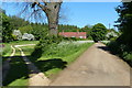
New Cottages along The Drift
This track is known as The Drift or Sewstern Lane, the Viking Way Long Distance Footpath runs along the route of the track. It forms the county boundary of Leicestershire and Lincolnshire.
Image: © Mat Fascione
Taken: 17 May 2014
0.04 miles
5
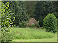
Old quarry building at New Cottages
This appears to be the only remaining building relating to the extensive group of ironstone quarries served by the Denton Branch railway line. It was the office from which the quarries in the area between Harston and Denton were controlled. It was at the terminus of the system of narrow gauge railways that brought the ironstone from the quarry faces to the transfer point into the standard gauge Denton Branch.
Image: © Alan Murray-Rust
Taken: 21 Aug 2013
0.04 miles
6
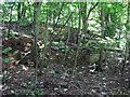
Derelict Tipping Dock, Harston Sidings, Denton Branch
Hidden in a newish plantation north of the Denton to Harston road are remains of the Denton Branch, which served the ironstone quarries at Denton, Harston, Cedar Hill (collectively known as Woolsthorpe Quarries) and Harlaxton. Before the Second World War, little narrow gauge engines brought ore here from the quarries for transhipment to main line wagons on the Denton Branch. After the War the narrow gauge lines were converted to standard gauge and the location of the big fan of sidings known as Harston Sidings can still be made out (see other photographs nearby). This tipping dock was used by lorries in the 1950s and 60s.
Image: © John Sutton
Taken: 27 Aug 2009
0.05 miles
7
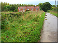
New Cottages, Sewstern Lane, near Denton
These 19th century brick terraced cottages were built against Socketwell Plantation in Leicestershire. Sewstern Lane, or Sewstern Drift as it is sometimes called, is in Lincolnshire. This is an old pre-Roman route between the Stamford and Newark regions. It was used as a drove road and skirts many of the villages along the route thus avoiding the tolls on the main turnpike roads. The Viking Way long distance footpath follows Sewstern Lane along much of its length. For more information on Sewstern Lane http://archive.is/V6lz and for the Viking Way http://www.ramblers.org.uk/info/paths/viking.html
Image: © Kate Jewell
Taken: 19 Oct 2005
0.05 miles
8

Sewstern Lane - 11
The lane crossing a bridge over a disused ironstone railway branch line (see Image)
Image: © Tim Heaton
Taken: 5 Jun 2014
0.05 miles
9

Sewstern Lane
Disused railway bridge on Sewstern Lane http://www.geograph.org.uk/photo/1464901
Image: © Richard Croft
Taken: 15 May 2014
0.06 miles
10
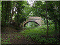
Old railway bridge in the woods
Carrying Sewstern Lane over the former Denton Branch of the Great Northern Railway. The railway served ironstone quarries in the area which were active between the 1880s and the 1970s. See also http://www.geograph.org.uk/photo/3648827
Image: © Alan Murray-Rust
Taken: 21 Aug 2013
0.06 miles