IMAGES TAKEN NEAR TO
Casthorpe Road, GRANTHAM, NG32 1JT
Introduction
This page details the photographs taken nearby to Casthorpe Road, NG32 1JT by members of the Geograph project.
The Geograph project started in 2005 with the aim of publishing, organising and preserving representative images for every square kilometre of Great Britain, Ireland and the Isle of Man.

There are currently over 7.5m images from over14,400 individuals and you can help contribute to the project by visiting https://www.geograph.org.uk
Image Map
Images are licensed for reuse under creativecommons.org/licenses/by-sa/2.0
Notes
- Clicking on the map will re-center to the selected point.
- The higher the marker number, the further away the image location is from the centre of the postcode.
Image Listing (42 Images Found)
Images are licensed for reuse under creativecommons.org/licenses/by-sa/2.0
Image
Details
Distance
1
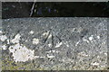
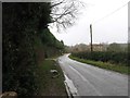
Benchmark on eastern parapet of bridge on Casthorpe Road
Ordnance Survey rivet benchmark described on the Bench Mark Database at www.bench-marks.org.uk/bm111749
Image: © phil Richards
Taken: 13 Sep 2019
0.08 miles
2
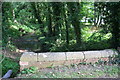
Parapet of bridge taking Casthorpe Road over stream
There is an OS benchmark Image on top of the second coping stone from the left hand end of the parapet.
Image: © phil Richards
Taken: 13 Sep 2019
0.09 miles
4
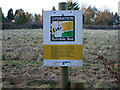
Operation Bumblebee
An environmental project sponsored by Sainsbury's, the supermarket chain, and Syngenta, a world leader in crop protection. Using 100's of specially trained farmers and growers the project is actively sowing and managing clover rich field corners and boundaries to re-establish the pollen and nectar food source of British bumblebees. See http://www.operationbumblebee.co.uk/ and http://www.syngenta.co.uk/about/operation-bumblebee.asp
Image: © Kate Jewell
Taken: 18 Jan 2009
0.10 miles
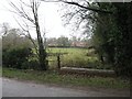
6
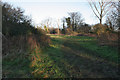
Public footpath, Denton
This footpath leads to Denton Reservoir and the Grantham Canal, both in Image
Image: © Kate Jewell
Taken: 18 Jan 2009
0.15 miles
7
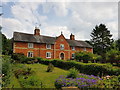
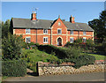
Former almshouses, Casthorpe Road, Denton
Built in 1869; now four cottages. Grade II listed https://historicengland.org.uk/listing/the-list/list-entry/1308554
Image: © Tim Heaton
Taken: 17 Jun 2020
0.15 miles
8
Estate cottages, Denton
Built in 1869 as almshouses by the Welby estate, now ordinary private residences, house numbers 125 to 127. The stone in the gable carries the Welby arms. Listed Grade II.
Image: © Alan Murray-Rust
Taken: 11 Aug 2013
0.15 miles
9
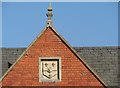
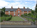
Denton: Welby Arms
The central gable of the cottages shown in Image] has a shield bearing the Welby Arms of a hand and three fleurs-de-lys. These former almshouses are Grade II listed - see http://www.britishlistedbuildings.co.uk/en-193280-estate-cottages-125-128-denton .
Image: © John Sutton
Taken: 30 Sep 2011
0.15 miles
10
Denton: Welby Estate cottages
Formerly almshouses, and with the Welby arms on the centre gable, these cottages are Grade II listed - see http://www.britishlistedbuildings.co.uk/en-193280-estate-cottages-125-128-denton .
Image: © John Sutton
Taken: 30 Sep 2011
0.15 miles