IMAGES TAKEN NEAR TO
Chestnut Grange, GRANTHAM, NG32 1FL
Introduction
This page details the photographs taken nearby to Chestnut Grange, NG32 1FL by members of the Geograph project.
The Geograph project started in 2005 with the aim of publishing, organising and preserving representative images for every square kilometre of Great Britain, Ireland and the Isle of Man.

There are currently over 7.5m images from over14,400 individuals and you can help contribute to the project by visiting https://www.geograph.org.uk
Image Map
Images are licensed for reuse under creativecommons.org/licenses/by-sa/2.0
Notes
- Clicking on the map will re-center to the selected point.
- The higher the marker number, the further away the image location is from the centre of the postcode.
Image Listing (62 Images Found)
Images are licensed for reuse under creativecommons.org/licenses/by-sa/2.0
Image
Details
Distance
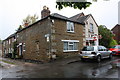
1
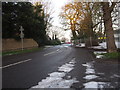
Rectory Lane towards the A52
The derelict building on the right is Greenacres nursing home, a relatively modern building which was closed recently. Derelict and prone to vandals, it was announced in October 2014 that the site could possibly be turned into houses.
Image: © William Fairbrother
Taken: 29 Dec 2014
0.04 miles
2
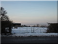
Field Entrance off Rectory Lane
Image: © William Fairbrother
Taken: 29 Dec 2014
0.08 miles
3
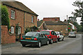
High Road, Barrowby
Many of the old cottages have no off road parking causing the owners to park on the street. This is a common sight in all the commuter villages round Grantham and it is very rare to get a view without vehicles. Photograph taken looking away from the junction with the A1 which is on the edge of the village.
Image: © Kate Jewell
Taken: 24 Aug 2006
0.08 miles
4
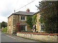
Holly House, Barrowby
A late seventeenth century house https://historicengland.org.uk/listing/the-list/list-entry/1235334
Image: © Jonathan Thacker
Taken: 12 Oct 2019
0.08 miles
5
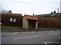
High Road bus shelter, Barrowby
I'm not sure how often these rural buses run.
Image: © Anthony Vosper
Taken: 14 Feb 2012
0.09 miles
6
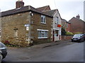
High Road Post Office,Barrowby
An OS Bench Mark is located on the cornerstone next to Chapel Lane.
Image: © Anthony Vosper
Taken: 18 Feb 2014
0.09 miles
7
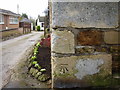
OS Bench Mark on a Quoin
On the Post Office wall.High Road Barrowby.
Chapel Lane runs alongside.
Image: © Anthony Vosper
Taken: 18 Feb 2014
0.09 miles
8
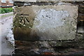
Benchmark on post office
Ordnance Survey cut mark benchmark described on the Bench Mark Database at www.bench-marks.org.uk/bm44098
Image: © Roger Templeman
Taken: 8 May 2019
0.09 miles
9
Post Office on High Road at Chapel Lane junction
There is an OS benchmark Image on the road face of the bottom quoin at the near corner of the building
Image: © Roger Templeman
Taken: 8 May 2019
0.09 miles
10
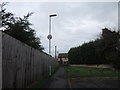
Path Leading To High Road
Barrowby has a lot of paths with no cycle signs linking residential streets.
Image: © William Fairbrother
Taken: 17 Nov 2014
0.09 miles