IMAGES TAKEN NEAR TO
Knipton, GRANTHAM, NG32 1EY
Introduction
This page details the photographs taken nearby to NG32 1EY by members of the Geograph project.
The Geograph project started in 2005 with the aim of publishing, organising and preserving representative images for every square kilometre of Great Britain, Ireland and the Isle of Man.

There are currently over 7.5m images from over14,400 individuals and you can help contribute to the project by visiting https://www.geograph.org.uk
Image Map
Images are licensed for reuse under creativecommons.org/licenses/by-sa/2.0
Notes
- Clicking on the map will re-center to the selected point.
- The higher the marker number, the further away the image location is from the centre of the postcode.
Image Listing (8 Images Found)
Images are licensed for reuse under creativecommons.org/licenses/by-sa/2.0
Image
Details
Distance
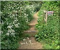
2
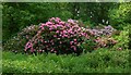
Rhododendron bushes near the Jubilee Way
Image: © Mat Fascione
Taken: 5 Jun 2010
0.17 miles
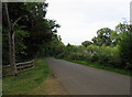
5
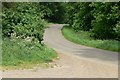
Wood Lane at Barkestone Wood
There is a small car park at the bend in the lane.
Image: © Mat Fascione
Taken: 5 Jun 2010
0.22 miles
6
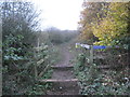
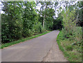
Jubilee Way enters Barkestone Wood
A misty November day provides a contrasting view to Mat Fascione's picture of the same scene taken in June Image
Image: © Jonathan Thacker
Taken: 16 Nov 2012
0.22 miles
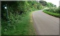
8
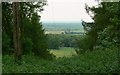
Gap through the trees
A glimpse of the Vale of Belvoir, looking north from the Jubilee Way on the Terrace Hills.
Image: © Mat Fascione
Taken: 5 Jun 2010
0.24 miles