IMAGES TAKEN NEAR TO
Branston Road, GRANTHAM, NG32 1EU
Introduction
This page details the photographs taken nearby to Branston Road, NG32 1EU by members of the Geograph project.
The Geograph project started in 2005 with the aim of publishing, organising and preserving representative images for every square kilometre of Great Britain, Ireland and the Isle of Man.

There are currently over 7.5m images from over14,400 individuals and you can help contribute to the project by visiting https://www.geograph.org.uk
Image Map
Images are licensed for reuse under creativecommons.org/licenses/by-sa/2.0
Notes
- Clicking on the map will re-center to the selected point.
- The higher the marker number, the further away the image location is from the centre of the postcode.
Image Listing (62 Images Found)
Images are licensed for reuse under creativecommons.org/licenses/by-sa/2.0
Image
Details
Distance
1
Sewage pumping station, Eaton
Discharging to the River Devon
Image: © Tim Heaton
Taken: 8 Apr 2022
0.01 miles
2
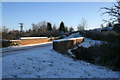
Leaving Eaton
As you leave Eaton to go to Branston, Lings Hill and the A607 you pass over the infant River Devon via this bridge.
Image: © Kate Jewell
Taken: 3 Jan 2010
0.03 miles
3
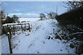
Public footpath to Branston
The path strikes off across the fields and the old ironstone mine workings from the entrance to Mill House.
Image: © Kate Jewell
Taken: 9 Jan 2010
0.05 miles
4
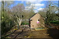
Eaton sewage pumping station
Tucked away behind some trees off Branston Lane.
Image: © Kate Jewell
Taken: 3 Jan 2010
0.05 miles

6
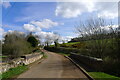
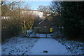
Branston Road leaving Eaton
Crossing a headwater stream of the River Devon
Image: © Tim Heaton
Taken: 8 Apr 2022
0.07 miles
7
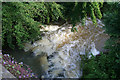
River Devon at Eaton
After the heavy rain of the 24th June 2007, this usually placid brook is rushing under the bridge.
Image: © Kate Jewell
Taken: 26 Jun 2007
0.07 miles
8
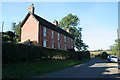
Cottages near Eaton, Leicestershire
These semi-detached cottages are unusual for the area being built of brick rather than the local ironstone. They a probably Edwardian and are some way out of the village of Eaton on the Branston road. They are at the edge of the featured square.
Image: © Kate Jewell
Taken: 21 Oct 2007
0.08 miles
9
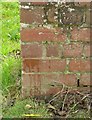
Bench mark, Branston Road, Eaton
See http://www.geograph.org.uk/photo/5180330 for location. The mark is well camouflaged.
Image: © Alan Murray-Rust
Taken: 31 Oct 2016
0.09 miles
