IMAGES TAKEN NEAR TO
Denton Lane, GRANTHAM, NG32 1EA
Introduction
This page details the photographs taken nearby to Denton Lane, NG32 1EA by members of the Geograph project.
The Geograph project started in 2005 with the aim of publishing, organising and preserving representative images for every square kilometre of Great Britain, Ireland and the Isle of Man.

There are currently over 7.5m images from over14,400 individuals and you can help contribute to the project by visiting https://www.geograph.org.uk
Image Map
Images are licensed for reuse under creativecommons.org/licenses/by-sa/2.0
Notes
- Clicking on the map will re-center to the selected point.
- The higher the marker number, the further away the image location is from the centre of the postcode.
Image Listing (6 Images Found)
Images are licensed for reuse under creativecommons.org/licenses/by-sa/2.0
Image
Details
Distance
1
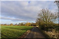
Track to Casthorpe Farm
Also forming part of the public footpath to Barrowby and the Casthorpe Hills
Image: © Tim Heaton
Taken: 4 Jan 2017
0.04 miles
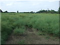
2

Track (footpath) heading east
Towards Casthorpe Farm.
Image: © JThomas
Taken: 21 Jun 2014
0.06 miles

5
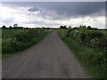
Casthorpe Farm Road
Casthorpe Farm stands at the top of this road.
Image: © Michael Patterson
Taken: 30 May 2006
0.17 miles
6
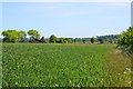
Farmland near Sedgebrook, Lincolnshire
Looking towards Coe Farm
Image: © Kate Jewell
Taken: 3 Jun 2006
0.17 miles