IMAGES TAKEN NEAR TO
Denton Lane, GRANTHAM, NG32 1DZ
Introduction
This page details the photographs taken nearby to Denton Lane, NG32 1DZ by members of the Geograph project.
The Geograph project started in 2005 with the aim of publishing, organising and preserving representative images for every square kilometre of Great Britain, Ireland and the Isle of Man.

There are currently over 7.5m images from over14,400 individuals and you can help contribute to the project by visiting https://www.geograph.org.uk
Image Map
Images are licensed for reuse under creativecommons.org/licenses/by-sa/2.0
Notes
- Clicking on the map will re-center to the selected point.
- The higher the marker number, the further away the image location is from the centre of the postcode.
Image Listing (14 Images Found)
Images are licensed for reuse under creativecommons.org/licenses/by-sa/2.0
Image
Details
Distance
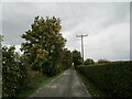
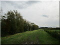
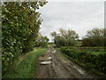
2
Denton Lane at the entrances to Casthorpe farm and Coe farm
The footpath to Barrowby (right) crosses the road here
Image: © Tim Heaton
Taken: 4 Jan 2017
0.08 miles
3
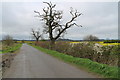
Trees on Denton Lane
A lot of dead wood on the nearest tree.
Image: © J.Hannan-Briggs
Taken: 6 Apr 2014
0.08 miles
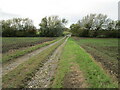
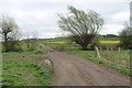
4
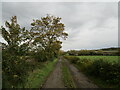
Farm track near Coe Farm
Is also a footpath to Barrowby.
Image: © Jonathan Thacker
Taken: 9 Oct 2020
0.09 miles
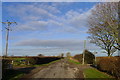
6
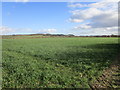
Cereal field and Casthorpe Hills
Seen from Denton Lane.
Image: © Jonathan Thacker
Taken: 14 Mar 2019
0.15 miles
8
Farm track and footpath to Coe Farm
Image: © Jonathan Thacker
Taken: 9 Oct 2020
0.16 miles
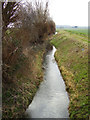
9
Approaching Old Beck
On a footpath to Barrowby.
Image: © Jonathan Thacker
Taken: 9 Oct 2020
0.16 miles
10
Footpath and track over Old Beck
Heading east.
Image: © J.Hannan-Briggs
Taken: 6 Apr 2014
0.17 miles