IMAGES TAKEN NEAR TO
Denton Lane, GRANTHAM, NG32 1DX
Introduction
This page details the photographs taken nearby to Denton Lane, NG32 1DX by members of the Geograph project.
The Geograph project started in 2005 with the aim of publishing, organising and preserving representative images for every square kilometre of Great Britain, Ireland and the Isle of Man.

There are currently over 7.5m images from over14,400 individuals and you can help contribute to the project by visiting https://www.geograph.org.uk
Image Map
Images are licensed for reuse under creativecommons.org/licenses/by-sa/2.0
Notes
- Clicking on the map will re-center to the selected point.
- The higher the marker number, the further away the image location is from the centre of the postcode.
Image Listing (11 Images Found)
Images are licensed for reuse under creativecommons.org/licenses/by-sa/2.0
Image
Details
Distance
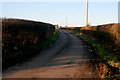
1

Minor road heading south
Towards Casthorpe Bridge.
Image: © JThomas
Taken: 21 Jun 2014
0.10 miles
2
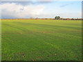
Large arable field near Casthorpe Road
Looking north across several flat arable fields with a snow shower approaching from the left.
Image: © Trevor Rickard
Taken: 5 Dec 2011
0.13 miles

4
Casthorpe Road
A narrow country road leading to Barrowby.
Image: © Kate Jewell
Taken: 30 Jan 2010
0.17 miles
5
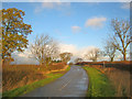
Casthorpe Road
Heading north towards Sedgebrook. Leading off to the left is a farm track and public footpath to Woolsthorpe by Belvior.
Image: © Trevor Rickard
Taken: 5 Dec 2011
0.20 miles
6
Well Trodden Track
This farm track is not a footpath despite the fact it is well worn.
Image: © Michael Patterson
Taken: 30 May 2006
0.22 miles
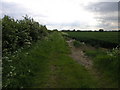
7
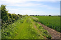
Farm track, Casthorpe, Lincolnshire
Looking westwards, this rough track follows the hedge. The crop is wheat.
Image: © Kate Jewell
Taken: 3 Jun 2006
0.23 miles
8
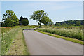
Country road, Lincolnshire
Halfway between Sedgebrook and Denton.
Image: © Kate Jewell
Taken: 3 Jun 2006
0.23 miles
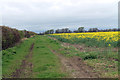
9
Farm track off Casthorpe Road
Heading south-west and providing access to several arable fields.
Image: © Trevor Rickard
Taken: 5 Dec 2011
0.23 miles
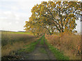
10
Track near the deserted Medieval Village of West Carthorpe
The track runs along an Oil Seed Rape field.
Image: © J.Hannan-Briggs
Taken: 6 Apr 2014
0.24 miles