IMAGES TAKEN NEAR TO
Casthorpe, GRANTHAM, NG32 1DS
Introduction
This page details the photographs taken nearby to NG32 1DS by members of the Geograph project.
The Geograph project started in 2005 with the aim of publishing, organising and preserving representative images for every square kilometre of Great Britain, Ireland and the Isle of Man.

There are currently over 7.5m images from over14,400 individuals and you can help contribute to the project by visiting https://www.geograph.org.uk
Image Map
Images are licensed for reuse under creativecommons.org/licenses/by-sa/2.0
Notes
- Clicking on the map will re-center to the selected point.
- The higher the marker number, the further away the image location is from the centre of the postcode.
Image Listing (8 Images Found)
Images are licensed for reuse under creativecommons.org/licenses/by-sa/2.0
Image
Details
Distance
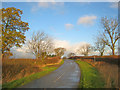
1
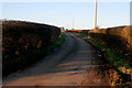
Casthorpe Road
A narrow country road leading to Barrowby.
Image: © Kate Jewell
Taken: 30 Jan 2010
0.06 miles
2
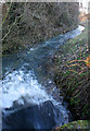
Old Beck
A fast flowing stream by Casthorpe House Farm.
Image: © Kate Jewell
Taken: 30 Jan 2010
0.10 miles
3
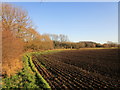
Field edge at Casthorpe
The Old Beck forms most of the field boundary visible.
Image: © Jonathan Thacker
Taken: 9 Dec 2019
0.11 miles
4
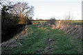
Farmland by Old Beck
The stream runs in the deep channel to the left. Beyond the hedge is Casthorpe House Farm.
Image: © Kate Jewell
Taken: 30 Jan 2010
0.13 miles
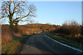
5
Casthorpe Road
Heading north towards Sedgebrook. Leading off to the left is a farm track and public footpath to Woolsthorpe by Belvior.
Image: © Trevor Rickard
Taken: 5 Dec 2011
0.18 miles
6
Casthorpe Road
With the Casthorpe Hills on the horizon.
Image: © Kate Jewell
Taken: 30 Jan 2010
0.21 miles

8

Minor road heading south
Towards Casthorpe Bridge.
Image: © JThomas
Taken: 21 Jun 2014
0.23 miles