IMAGES TAKEN NEAR TO
Hungerton, GRANTHAM, NG32 1AN
Introduction
This page details the photographs taken nearby to NG32 1AN by members of the Geograph project.
The Geograph project started in 2005 with the aim of publishing, organising and preserving representative images for every square kilometre of Great Britain, Ireland and the Isle of Man.

There are currently over 7.5m images from over14,400 individuals and you can help contribute to the project by visiting https://www.geograph.org.uk
Image Map
Images are licensed for reuse under creativecommons.org/licenses/by-sa/2.0
Notes
- Clicking on the map will re-center to the selected point.
- The higher the marker number, the further away the image location is from the centre of the postcode.
Image Listing (9 Images Found)
Images are licensed for reuse under creativecommons.org/licenses/by-sa/2.0
Image
Details
Distance
1
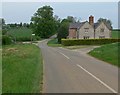
Road junction in Hungerton, Lincolnshire
Turn right for Wyville.
Image: © Mat Fascione
Taken: 10 May 2008
0.04 miles
2
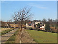
Hungerton
From the lane leading from Wyville. Hungerton Hall in the background
Image: © Tim Heaton
Taken: 10 Feb 2008
0.04 miles

4
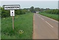
Approaching the Lincolnshire village of Hungerton
Image: © Mat Fascione
Taken: 10 May 2008
0.08 miles
5
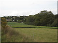
Hungerton seen from the lane to Wyville
Image: © Jonathan Thacker
Taken: 12 Oct 2019
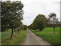
0.11 miles
7
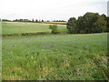
Field of linseed, Wyville
The dominant plant in this field is linseed but there are many other species there too.
Image: © Jonathan Thacker
Taken: 12 Oct 2019
0.14 miles
8

Protected Roadside verge
It may be protected Image but the salt bin is still on it.
Image: © Andrew Tatlow
Taken: 30 Sep 2008
0.17 miles
9
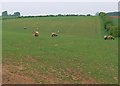
Sheep near Wyville
In southwest Lincolnshire close to the county border with Leicestershire.
Image: © Mat Fascione
Taken: 10 May 2008
0.20 miles