IMAGES TAKEN NEAR TO
Hungerton, GRANTHAM, NG32 1AH
Introduction
This page details the photographs taken nearby to NG32 1AH by members of the Geograph project.
The Geograph project started in 2005 with the aim of publishing, organising and preserving representative images for every square kilometre of Great Britain, Ireland and the Isle of Man.

There are currently over 7.5m images from over14,400 individuals and you can help contribute to the project by visiting https://www.geograph.org.uk
Image Map
Images are licensed for reuse under creativecommons.org/licenses/by-sa/2.0
Notes
- Clicking on the map will re-center to the selected point.
- The higher the marker number, the further away the image location is from the centre of the postcode.
Image Listing (8 Images Found)
Images are licensed for reuse under creativecommons.org/licenses/by-sa/2.0
Image
Details
Distance
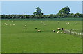
1
Hill Top Farm, from the west
The hedge in the foreground is glowing red in the low winter sun.
Image: © Christine Johnstone
Taken: 28 Dec 2013
0.01 miles
2
Farmland near Gorse Lane
Using the last of the evening's light to look along the public footpath near Hill Top Farm.
Image: © Kate Jewell
Taken: 14 Apr 2006
0.12 miles
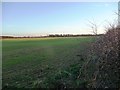
3
Field near Hill Top Farm
No sign of the footpath running diagonally across the field to the right
Image: © Tim Heaton
Taken: 11 Sep 2020
0.13 miles
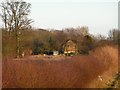
4
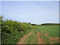
Track to Hill Top Farm
Appears to be all but abandoned.
Image: © Jonathan Thacker
Taken: 21 May 2020
0.20 miles
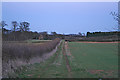
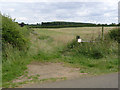
5
Public Footpath near Hilltop Farm
Clearly marked across the field.
Image: © J.Hannan-Briggs
Taken: 27 Apr 2014
0.24 miles
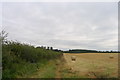
6
Farmland west of Hill Top Farm
The Romans knew this landscape, as a Roman villa once stood in the distance.
Image: © Christine Johnstone
Taken: 28 Dec 2013
0.25 miles
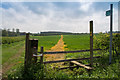
7
Farm access and footpath
The overgrown track to the left is the former access to Welby Hill Top Farm (formerly Madge Farm), now replaced by an access off Gorse Lane http://www.geograph.org.uk/photo/3601988 . The footpath does not follow the track, but cuts across the field to the dark patch in the hedge in line with the gatepost. This also reaches Gorse Lane at the same point as the farm access.
Image: © Alan Murray-Rust
Taken: 11 Aug 2013
0.25 miles