IMAGES TAKEN NEAR TO
Roden Street, NOTTINGHAM, NG3 1GH
Introduction
This page details the photographs taken nearby to Roden Street, NG3 1GH by members of the Geograph project.
The Geograph project started in 2005 with the aim of publishing, organising and preserving representative images for every square kilometre of Great Britain, Ireland and the Isle of Man.

There are currently over 7.5m images from over14,400 individuals and you can help contribute to the project by visiting https://www.geograph.org.uk
Image Map
Images are licensed for reuse under creativecommons.org/licenses/by-sa/2.0
Notes
- Clicking on the map will re-center to the selected point.
- The higher the marker number, the further away the image location is from the centre of the postcode.
Image Listing (237 Images Found)
Images are licensed for reuse under creativecommons.org/licenses/by-sa/2.0
Image
Details
Distance
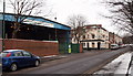
1
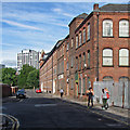
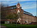
Roden Street
Looking towards Robin Hood Street on a bright Saturday morning in late August. The former mill at the far end of the street has been converted into flats, but the factory building nearer the camera appeared derelict.
Image: © John Sutton
Taken: 22 Aug 2015
0.02 miles
2
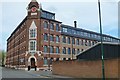
William Bancroft Building
This former mill is not listed and is now converted into housing. Not been able to find out who William Bancroft is (or was).
June 2016: My thanks go to Chris Allen for finding a reference to "William Bancroft & Co, blouse manufacturers Nottingham" in the Nottinghamshire archives.
Image: © David Lally
Taken: 30 Apr 2016
0.02 miles
4
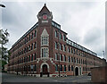
Bancroft Buildings, Robin Hood Street, Nottingham
Formerly William Windley's silk factory, dated 1869 in the gable (Image]). See also Image
Converted to flats in 2003.
Image: © Stephen Richards
Taken: 19 Jun 2015
0.02 miles
5
William Bancroft Buildings, Robin Hood Street
Image: © Bryn Holmes
Taken: 16 Mar 2020
0.02 miles
6
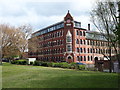
Nottingham - NG3 (Sneinton)
This former mill (clothing factory) on the corner of Robin Hood Street and Roden Street, as seen across Victoria Park, has been converted into apartments. It is now called The William Bancroft Building but may well have been known as Bancroft/s Mill or Roden/s Mill in the past?
Image: © David Hallam-Jones
Taken: 7 May 2012
0.03 miles
7
Robin Hood Street: former factory
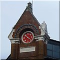
Bancroft Buildings, a grand silk factory fronting Robin Hood Street and Roden Street, flats since 2003. It was built in 1869 for William Windley. Like many lace and cotton factories in the East Midlands it had many-windowed attic workshops where much of the finest work was done, in the most favourable light. The red clock face on the corner gable is a weather vane, marked with the points of the compass instead of numbers.
Image: © John Sutton
Taken: 22 Aug 2015
0.03 miles

9
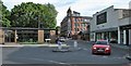
Up Robin Hood Street
The junction of Robin Hood Street and Bath Street, with premises of the long-established Nottingham funeral director A W Lymn on either side of the road and Image] in the centre middle distance.
Image: © John Sutton
Taken: 22 Aug 2015
0.06 miles
10
Nottingham, NG3
Nottingham City Council's Car Pound on Handel Street, Sneinton. To the photographer's right is the "Market Place Car Park" and ahead - beyond Liverpool Street - is "The Vine" public house. The B686 (Carlton Road) can be accessed in the distance.
Image: © David Hallam-Jones
Taken: 24 Jan 2013
0.06 miles