IMAGES TAKEN NEAR TO
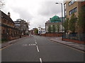
St. Anns Well Road, NOTTINGHAM, NG3 1EJ
Introduction
This page details the photographs taken nearby to St. Anns Well Road, NG3 1EJ by members of the Geograph project.
The Geograph project started in 2005 with the aim of publishing, organising and preserving representative images for every square kilometre of Great Britain, Ireland and the Isle of Man.

There are currently over 7.5m images from over14,400 individuals and you can help contribute to the project by visiting https://www.geograph.org.uk
Image Map
Images are licensed for reuse under creativecommons.org/licenses/by-sa/2.0
Notes
- Clicking on the map will re-center to the selected point.
- The higher the marker number, the further away the image location is from the centre of the postcode.
Image Listing (365 Images Found)
Images are licensed for reuse under creativecommons.org/licenses/by-sa/2.0
Image
Details
Distance
1
Nottingham - NG1 (St Ann's)
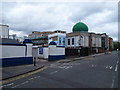
The gates and boundary walls of the Gala bingo hall car park - painted blue and white - with the Islamic Centre and mosque. It appears that additional residential accommodation is being built at the Curzon Place end of their site.
Image: © David Hallam-Jones
Taken: 7 May 2012
0.03 miles
2
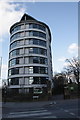
Victoria Hall, Bath Street
There is an OS benchmark Image on the right hand gatepost of the entrance to St Mary's Rest Garden, to the right of Victoria Hall which is student accommodation
Image: © Roger Templeman
Taken: 30 Mar 2013
0.03 miles
3
St Ann's Well Road, Nottingham city centre
Image: © Bryn Holmes
Taken: 16 Mar 2020
0.03 miles
4
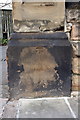
Benchmark on gatepost at entrance to St Mary's Rest Garden
Ordnance Survey cut mark benchmark on right hand side gatepost on Bath Street entrance to the rest garden, described on the Bench Mark Database at http://www.bench-marks.org.uk/bm47886
Image: © Roger Templeman
Taken: 30 Mar 2013
0.03 miles
5
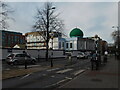
Nottingham - NG3 (St Ann's)
The mosque with a Gala Bingo Hall beyond it (i.e. the white building), as one looks towards Beck Street and the A60.
Image: © David Hallam-Jones
Taken: 7 May 2012
0.03 miles
6
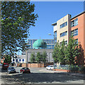
St Ann's Well Road: Nurani Jami Masjid
A large mosque on the corner of St Ann's Well Road and Curzon Street.
Image: © John Sutton
Taken: 30 Jun 2015
0.04 miles
7
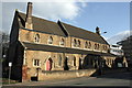
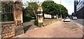
Christ Citadel Christian Centre, St Anns Well Road
There is an OS benchmark Image on the road face end of the brick wall which forms the northern boundary of the site
Image: © Roger Templeman
Taken: 30 Mar 2013
0.04 miles
8
St Mary's Rest Garden
A view towards The Council House in the city centre, taken on a bright Saturday morning in August.
Image: © John Sutton
Taken: 22 Aug 2015
0.04 miles
9
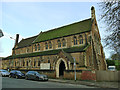
Christ Citadel Christian Centre, St Ann's Well Road
Formerly St Catharine's (Church of England) from 1896 to 2003, it had its own cemetery behind the church building which is now confusingly known as St Mary's Rest Garden. Architect Robert Charles Clarke. (source: Wikipedia)
Image: © Stephen Craven
Taken: 18 Jan 2020
0.04 miles
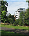
10
Entrance to Victoria Park from north side of Bath Street
Image: © Luke Shaw
Taken: 7 May 2022
0.04 miles