IMAGES TAKEN NEAR TO
Purcell Close, GRANTHAM, NG31 9QP
Introduction
This page details the photographs taken nearby to Purcell Close, NG31 9QP by members of the Geograph project.
The Geograph project started in 2005 with the aim of publishing, organising and preserving representative images for every square kilometre of Great Britain, Ireland and the Isle of Man.

There are currently over 7.5m images from over14,400 individuals and you can help contribute to the project by visiting https://www.geograph.org.uk
Image Map
Images are licensed for reuse under creativecommons.org/licenses/by-sa/2.0
Notes
- Clicking on the map will re-center to the selected point.
- The higher the marker number, the further away the image location is from the centre of the postcode.
Image Listing (10 Images Found)
Images are licensed for reuse under creativecommons.org/licenses/by-sa/2.0
Image
Details
Distance
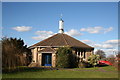
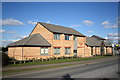
1
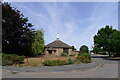
The Church of the Ascension, Harrowby, Grantham
Built in 1956 to serve the rapidly growing housing estates of Harrowby [Benefice Profile Grantham: Harrowby with Londonthorpe]
Image: © Tim Heaton
Taken: 11 Jul 2022
0.13 miles
2
The Church of the Ascension, Harrowby
Image: © Jonathan Thacker
Taken: 8 Feb 2018
0.13 miles
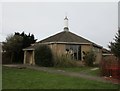
4
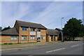
Harrowby Lane Methodist Church, Harrowby, Grantham
Originally a wooden hut, which had been moved from another site. This was replaced by a brick building in 1963, with later additions https://www.harrowbylane.org.uk/about/our-history/
Image: © Tim Heaton
Taken: 11 Jul 2022
0.15 miles
5
Church of the Ascension, Harrowby
Modern church in housing estate
Image: © Richard Croft
Taken: 1 Mar 2006
0.16 miles
6
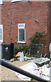
Benchmark on #96 Harrowby Lane
The Ordnance Survey cut mark benchmark on the corner, left hand face, of the house, is described on the Bench Mark Database at http://www.bench-marks.org.uk/bm74706
Image: © Roger Templeman
Taken: 7 Apr 2016
0.19 miles
7
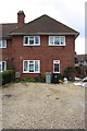
#96 Harrowby Lane
There is an OS benchmark Image on the front of the house at its right hand corner
Image: © Roger Templeman
Taken: 7 Apr 2016
0.20 miles
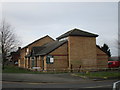
8
Harrowby Lane Methodist church
The church was an old hut until recently when this new multi-purpose building was erected by its enthusiastic congregation http://www.users.zetnet.co.uk/harrowbylane/
Image: © Richard Croft
Taken: 1 Mar 2006
0.23 miles
9
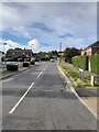
Green Lane, Harrowby, Grantham
A foot and cycle path, and parish boundary, cutting across the Harrowby estate. Shown as a 'Green Lane' on the 1886 OS map.
Image: © Tim Heaton
Taken: 11 Jul 2022
0.24 miles