IMAGES TAKEN NEAR TO
Belton Lane, GRANTHAM, NG31 9HW
Introduction
This page details the photographs taken nearby to Belton Lane, NG31 9HW by members of the Geograph project.
The Geograph project started in 2005 with the aim of publishing, organising and preserving representative images for every square kilometre of Great Britain, Ireland and the Isle of Man.

There are currently over 7.5m images from over14,400 individuals and you can help contribute to the project by visiting https://www.geograph.org.uk
Image Map
Images are licensed for reuse under creativecommons.org/licenses/by-sa/2.0
Notes
- Clicking on the map will re-center to the selected point.
- The higher the marker number, the further away the image location is from the centre of the postcode.
Image Listing (71 Images Found)
Images are licensed for reuse under creativecommons.org/licenses/by-sa/2.0
Image
Details
Distance
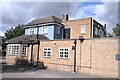
1
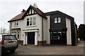
Nos. 95 and 97 Belton Lane
There is an Ordnance Survey benchmark Image on the front of the left hand house under its house number (95) sign
Image: © phil Richards
Taken: 7 Apr 2016
0.05 miles
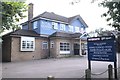
2
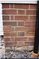
Benchmark on No. 95 Belton Lane
Ordnance Survey cut mark benchmark described on the Bench Mark Database at www.bench-marks.org.uk/bm74708
Image: © phil Richards
Taken: 7 Apr 2016
0.05 miles
3
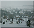
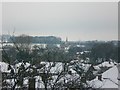
Fresh snow on Grantham rooftops, Easter 2008
Looking north-west from Harrowby Lane. The rooftops in the foreground are in Lime Grove, with Belton Lane a bit further off. In the distance, the hill known as Peascliff, and - just visible near the top left-hand corner of the frame - the power pylons near Great Gonerby.
This shot was taken quite early on Easter morning, with a little snow still falling. A view from the same window, an hour later, can be seen here: Image
Image: © Stefan Czapski
Taken: 23 Mar 2008
0.06 miles
5
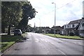
Toward the Spire
Belton Lane, with the steeple of St Wulfram's Church on the skyline
Image: © Bob Harvey
Taken: 5 Sep 2020
0.11 miles
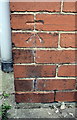
6
Benchmark on #17 Harrowby Lane
Ordnance Survey cut mark benchmark described on the Bench Mark Database at http://www.bench-marks.org.uk/bm74707
Image: © Roger Templeman
Taken: 7 Apr 2016
0.13 miles
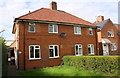
7
#17 Harrowby Lane
There is an OS benchmark Image on the side of the middle section of the house, left of the black downpipe
Image: © Roger Templeman
Taken: 7 Apr 2016
0.13 miles
8
Snowy roofscape, Grantham, Easter 2008
A few inches of snow fell on Grantham in the early morning of Easter Sunday, 2008. In this view, from Harrowby Lane, the rooftops of Lime Grove are to be seen in the foreground, with the spire of Manthorpe church in the middle-distance.
This shot was taken about an hour after: Image
For the view from the same window on a sunny morning, see: Image
Image: © Stefan Czapski
Taken: 23 Mar 2008
0.13 miles