IMAGES TAKEN NEAR TO
Cavendish Way, GRANTHAM, NG31 9FN
Introduction
This page details the photographs taken nearby to Cavendish Way, NG31 9FN by members of the Geograph project.
The Geograph project started in 2005 with the aim of publishing, organising and preserving representative images for every square kilometre of Great Britain, Ireland and the Isle of Man.

There are currently over 7.5m images from over14,400 individuals and you can help contribute to the project by visiting https://www.geograph.org.uk
Image Map
Images are licensed for reuse under creativecommons.org/licenses/by-sa/2.0
Notes
- Clicking on the map will re-center to the selected point.
- The higher the marker number, the further away the image location is from the centre of the postcode.
Image Listing (9 Images Found)
Images are licensed for reuse under creativecommons.org/licenses/by-sa/2.0
Image
Details
Distance
2
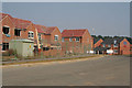
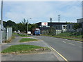
New housing, off Londonthorpe Lane, Grantham
Image: © Kate Jewell
Taken: 25 Jul 2006
0.17 miles
4
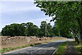
Londonthorpe Road at the boundary of Belton Park
The wall enclosing the Belton House estate needing repair
Image: © Tim Heaton
Taken: 11 Jul 2022
0.19 miles
5
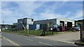
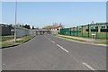
Industrial Unit, Alma Park Industrial Estate
Image: © JThomas
Taken: 9 Aug 2012
0.20 miles
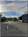
6
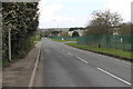
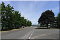
Londonthorpe Road
Looking west past Parker mobile controls.
Image: © J.Hannan-Briggs
Taken: 23 Mar 2014
0.20 miles
7
Isaac Newton Way joining Alma Park Road, Grantham
Born a few miles south of Grantham, Newton went to the town's King's School.
Image: © Tim Heaton
Taken: 11 Jul 2022
0.22 miles