IMAGES TAKEN NEAR TO
Harrowby Road, GRANTHAM, NG31 9ED
Introduction
This page details the photographs taken nearby to Harrowby Road, NG31 9ED by members of the Geograph project.
The Geograph project started in 2005 with the aim of publishing, organising and preserving representative images for every square kilometre of Great Britain, Ireland and the Isle of Man.

There are currently over 7.5m images from over14,400 individuals and you can help contribute to the project by visiting https://www.geograph.org.uk
Image Map
Images are licensed for reuse under creativecommons.org/licenses/by-sa/2.0
Notes
- Clicking on the map will re-center to the selected point.
- The higher the marker number, the further away the image location is from the centre of the postcode.
Image Listing (93 Images Found)
Images are licensed for reuse under creativecommons.org/licenses/by-sa/2.0
Image
Details
Distance
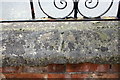
3
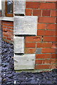
Benchmark on #42 Cecil Street
Ordnance Survey cut mark benchmark described on the Bench Mark Database at http://www.bench-marks.org.uk/bm74692
Image: © Roger Templeman
Taken: 7 Apr 2016
0.06 miles
4
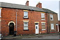
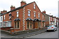
Houses on Cecil Street
There is an OS benchmark Image on the front of #42 between a pipe through its wall and the front door of #43
Image: © Roger Templeman
Taken: 7 Apr 2016
0.06 miles
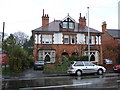
5
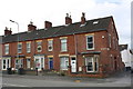
Houses on Harrowby Road
The right hand house is #9 Granville Street, and has an OS benchmark Image on a coping stone on the wall in front of it
Image: © Roger Templeman
Taken: 7 Apr 2016
0.06 miles
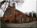
6
Church of St Anne, Harrowby Road
There is an OS benchmark Image on the left hand face, far corner, of the church
Image: © Roger Templeman
Taken: 7 Apr 2016
0.07 miles
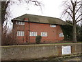
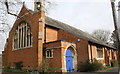
7
Church of St. Anne, New Somerby
Dates from 1906-7, architect - B.H. Tarrant.
Image: © Jonathan Thacker
Taken: 8 Jan 2020
0.07 miles
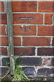
8
Benchmark on roadside wall of #9 Granville Street
Ordnance Survey rivet benchmark described on the Bench Mark Database at http://www.bench-marks.org.uk/bm74817
Image: © Roger Templeman
Taken: 7 Apr 2016
0.07 miles
9
Benchmark on #22A St Anne's Street
Ordnance Survey cut mark benchmark described on the Bench Mark Database at http://www.bench-marks.org.uk/bm74689
Image: © Roger Templeman
Taken: 7 Apr 2016
0.07 miles
10
Junction of St Anne's Street and Harrowby Road
There is an OS benchmark Image on the third stone quoin above ground of the nearest house
Image: © Roger Templeman
Taken: 7 Apr 2016
0.07 miles