IMAGES TAKEN NEAR TO
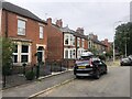
Harrowby Road, GRANTHAM, NG31 9DS
Introduction
This page details the photographs taken nearby to Harrowby Road, NG31 9DS by members of the Geograph project.
The Geograph project started in 2005 with the aim of publishing, organising and preserving representative images for every square kilometre of Great Britain, Ireland and the Isle of Man.

There are currently over 7.5m images from over14,400 individuals and you can help contribute to the project by visiting https://www.geograph.org.uk
Image Map
Images are licensed for reuse under creativecommons.org/licenses/by-sa/2.0
Notes
- Clicking on the map will re-center to the selected point.
- The higher the marker number, the further away the image location is from the centre of the postcode.
Image Listing (108 Images Found)
Images are licensed for reuse under creativecommons.org/licenses/by-sa/2.0
Image
Details
Distance
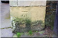
3
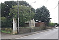
Boundary wall of cemetery, Harrowby Road
There is an OS benchmark Image on the wall pier at the corner of the wall
Image: © Roger Templeman
Taken: 7 Apr 2016
0.04 miles
4
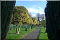
Variegated holly, Grantham cemetery
A popular shrub in cemeteries; its evergreen nature associated with everlasting life.
Image: © Tim Heaton
Taken: 19 Nov 2021
0.05 miles
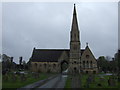
5
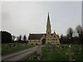
Cemetery chapels, Grantham
Date from about 1857.
Image: © Jonathan Thacker
Taken: 8 Jan 2020
0.06 miles
6
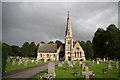
Grantham cemetery
The cemetery opened in 1857 after the old burial ground on Manthorpe Road became full, and the Burial Act of 1853 authorised the provision of publicly-funded cemeteries. The chapel was closed after a new crematorium was built in 1966.
Image: © Tim Heaton
Taken: 19 Nov 2021
0.06 miles
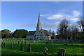
8
Cemetery Chapel
Neo-Gothic Cemetery Chapel in the Early English style at Harrowby Road Cemetery
Image: © Richard Croft
Taken: 1 Oct 2008
0.06 miles
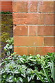
9
Benchmark on pier of cemetery wall, Harrowby Road
Ordnance Survey cut mark benchmark described on the Bench Mark Database at http://www.bench-marks.org.uk/bm74694
Image: © Roger Templeman
Taken: 7 Apr 2016
0.06 miles
10
Benchmark on Church of St Anne
Ordnance Survey cut mark benchmark described on the Bench Mark Database at http://www.bench-marks.org.uk/bm74693
Image: © Roger Templeman
Taken: 7 Apr 2016
0.07 miles