IMAGES TAKEN NEAR TO
Beacon Lane, GRANTHAM, NG31 9DN
Introduction
This page details the photographs taken nearby to Beacon Lane, NG31 9DN by members of the Geograph project.
The Geograph project started in 2005 with the aim of publishing, organising and preserving representative images for every square kilometre of Great Britain, Ireland and the Isle of Man.

There are currently over 7.5m images from over14,400 individuals and you can help contribute to the project by visiting https://www.geograph.org.uk
Image Map
Images are licensed for reuse under creativecommons.org/licenses/by-sa/2.0
Notes
- Clicking on the map will re-center to the selected point.
- The higher the marker number, the further away the image location is from the centre of the postcode.
Image Listing (16 Images Found)
Images are licensed for reuse under creativecommons.org/licenses/by-sa/2.0
Image
Details
Distance
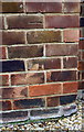
1
Benchmark on garage at rear of #2 Kenwick Drive
Ordnance Survey cut mark benchmark described on the Bench Mark Database at http://www.bench-marks.org.uk/bm74699
Image: © Roger Templeman
Taken: 7 Apr 2016
0.05 miles
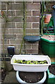
2
Garage at rear of #2 Kenwick Drive
There is an OS benchmark Image on the near corner, left hand face, of the garage
Image: © Roger Templeman
Taken: 7 Apr 2016
0.05 miles
3
Benchmark on #31 New Beacon Road
Ordnance Survey cut mark benchmark described on the Bench Mark Database at http://www.bench-marks.org.uk/bm74700
Image: © Roger Templeman
Taken: 7 Apr 2016
0.15 miles
4
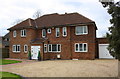
#31 New Beacon Road
There is an OS benchmark Image near the right hand end of the jut right of the door on the front face of the house
Image: © Roger Templeman
Taken: 7 Apr 2016
0.15 miles
5

Benchmark on building on south side of Beacon Lane
Ordnance Survey cut mark benchmark described on the Bench Mark Database at http://www.bench-marks.org.uk/bm74698
Image: © Roger Templeman
Taken: 7 Apr 2016
0.16 miles
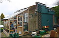
6
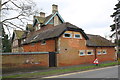
Building on Beacon Lane
There is an OS benchmark Image on the road face of the building, right of the black gate
Image: © Roger Templeman
Taken: 7 Apr 2016
0.16 miles
7
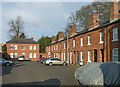
Barracks Square, Stonebridge Road, Grantham
Built 1858 by County Surveyor Henry Goddard as NCOs' quarters. Two facing rows of small brick cottages compare with the more impressive stone faced buildings facing the main road http://www.geograph.org.uk/photo/5286834 . Listed Grade II.
Image: © Alan Murray-Rust
Taken: 15 Feb 2017
0.21 miles
8
Barracks Square, Stonebridge Road, Grantham
Built 1858 by County Surveyor Henry Goddard as NCOs' quarters. The houses facing the road are faced in stone to provide an impression of quality compared with the internal housing http://www.geograph.org.uk/photo/5286836 . Listed Grade II.
Image: © Alan Murray-Rust
Taken: 15 Feb 2017
0.21 miles
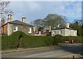
9
Barracks Square, Stonebridge Road, Grantham
The gateway into the courtyard http://www.geograph.org.uk/photo/5286836 .
Image: © Alan Murray-Rust
Taken: 15 Feb 2017
0.21 miles
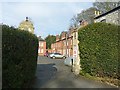
10

4 to 12 Barrack Square, Beacon Lane, Grantham
Grade II Listed Militia officers' quarters, now houses. 1858, by Henry Goddard (1813-1899), architect and County Surveyor, for the Royal South Lincs Militia Regiment. Goddard built similar barracks in Lincoln for the Loyal North Lincoln Militia.
Image: © Jo and Steve Turner
Taken: 24 Mar 2017
0.21 miles