IMAGES TAKEN NEAR TO
St. Catherines Road, GRANTHAM, NG31 9DE
Introduction
This page details the photographs taken nearby to St. Catherines Road, NG31 9DE by members of the Geograph project.
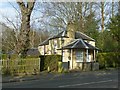
The Geograph project started in 2005 with the aim of publishing, organising and preserving representative images for every square kilometre of Great Britain, Ireland and the Isle of Man.

There are currently over 7.5m images from over14,400 individuals and you can help contribute to the project by visiting https://www.geograph.org.uk
Image Map
Images are licensed for reuse under creativecommons.org/licenses/by-sa/2.0
Notes
- Clicking on the map will re-center to the selected point.
- The higher the marker number, the further away the image location is from the centre of the postcode.
Image Listing (129 Images Found)
Images are licensed for reuse under creativecommons.org/licenses/by-sa/2.0
Image
Details
Distance
1
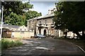
Stonebridge House
Former Grantham Divisional Police HQ, awaiting redevelopment
Image: © Richard Croft
Taken: 1 Oct 2008
0.03 miles
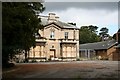
2
Stonebridge House, Grantham
A large mid-19th century house in classical style. Later in use as a school, then Lincolnshire Police Headquarters from the 1950s to the early 21st century. After standing empty for some time it is currently being refurbished as part of a major redevelopment of Grantham College. The house is Listed Grade II.
Image: © Alan Murray-Rust
Taken: 15 Feb 2017
0.05 miles
3
Stonebridge House
Former Grantham Police Divisional HQ, awaiting redevelopment
Image: © Richard Croft
Taken: 1 Oct 2008
0.05 miles
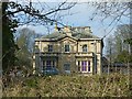
4
South Lodge, Stonebridge House, St Catherine's Road
Image: © Roger Templeman
Taken: 19 Apr 2014
0.06 miles
5
South Lodge, St Catherine's Road, Grantham
Lodge to Stonebridge house which built in 1858, so presumably of the same date.
Image: © Alan Murray-Rust
Taken: 15 Feb 2017
0.06 miles
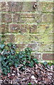
6
Benchmark on pier of cemetery wall, Harrowby Road
Ordnance Survey cut mark benchmark described on the Bench Mark Database at http://www.bench-marks.org.uk/bm74694
Image: © Roger Templeman
Taken: 7 Apr 2016
0.07 miles
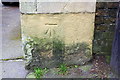
7
Benchmark on wall of Police HQ, Stonebridge Road
Ordnance Survey cut mark benchmark described on the Bench Mark Database at http://www.bench-marks.org.uk/bm74695
Image: © Roger Templeman
Taken: 7 Apr 2016
0.08 miles
8
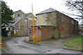
Entrance to Police HQ from Stonebridge Road
There is an OS benchmark Image on the near corner on the main building in middle of the image
Image: © Roger Templeman
Taken: 7 Apr 2016
0.08 miles
9
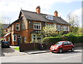
Semi detached houses on Dudley Road
There is an OS benchmark Image on the near corner of the left hand house which carries the name 'LEESIDE'.
Image: © Roger Templeman
Taken: 19 Apr 2014
0.08 miles
10
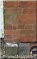
Benchmark on #4 Dudley Road
Ordnance Survey cut mark benchmark described on the Bench Mark Database at http://www.bench-marks.org.uk/bm57237
Image: © Roger Templeman
Taken: 19 Apr 2014
0.09 miles