IMAGES TAKEN NEAR TO
Sandon Close, GRANTHAM, NG31 9AX
Introduction
This page details the photographs taken nearby to Sandon Close, NG31 9AX by members of the Geograph project.
The Geograph project started in 2005 with the aim of publishing, organising and preserving representative images for every square kilometre of Great Britain, Ireland and the Isle of Man.

There are currently over 7.5m images from over14,400 individuals and you can help contribute to the project by visiting https://www.geograph.org.uk
Image Map
Images are licensed for reuse under creativecommons.org/licenses/by-sa/2.0
Notes
- Clicking on the map will re-center to the selected point.
- The higher the marker number, the further away the image location is from the centre of the postcode.
Image Listing (30 Images Found)
Images are licensed for reuse under creativecommons.org/licenses/by-sa/2.0
Image
Details
Distance
1
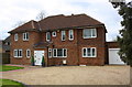
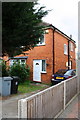
#31 New Beacon Road
There is an OS benchmark Image near the right hand end of the jut right of the door on the front face of the house
Image: © Roger Templeman
Taken: 7 Apr 2016
0.10 miles
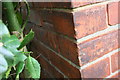
2
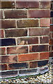
Benchmark on #31 New Beacon Road
Ordnance Survey cut mark benchmark described on the Bench Mark Database at http://www.bench-marks.org.uk/bm74700
Image: © Roger Templeman
Taken: 7 Apr 2016
0.10 miles
3
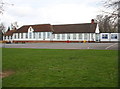
St Mary's Catholic Primary School, Sandon Road
Image: © Roger Templeman
Taken: 7 Apr 2016
0.12 miles
4

Benchmark on #77 New Beacon Road
Ordnance Survey cut mark benchmark described on the Bench Mark Database at http://www.bench-marks.org.uk/bm74701
Image: © Roger Templeman
Taken: 7 Apr 2016
0.13 miles
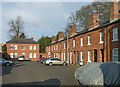
6
#77 New Beacon Road
There is an OS benchmark Image on the near corner, front face, of the house
Image: © Roger Templeman
Taken: 7 Apr 2016
0.13 miles
8
Benchmark on Kesteven and Grantham Girls' School
Ordnance Survey cut mark benchmark described on the Bench Mark Database at http://www.bench-marks.org.uk/bm74697
Image: © Roger Templeman
Taken: 7 Apr 2016
0.19 miles
9
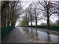
Barracks Square, Stonebridge Road, Grantham
Built 1858 by County Surveyor Henry Goddard as NCOs' quarters. Two facing rows of small brick cottages compare with the more impressive stone faced buildings facing the main road http://www.geograph.org.uk/photo/5286834 . Listed Grade II.
Image: © Alan Murray-Rust
Taken: 15 Feb 2017
0.19 miles
10
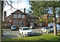
Kesteven and Grantham Girls' School
This is the original main building of 1910. Designed by architect Herbert Henry Dunn of Lincoln, who specialised in schools architecture. The building comprised a large hall (with arched windows) flanked on 3 sides by two storey classroom blocks and on the fourth by the entrance with flanking offices. Listed Grade II. Noted as the school at which Margaret Roberts (Thatcher) received her secondary education.
Image: © Alan Murray-Rust
Taken: 15 Feb 2017
0.19 miles