IMAGES TAKEN NEAR TO
Conisbrough Close, GRANTHAM, NG31 8UW
Introduction
This page details the photographs taken nearby to Conisbrough Close, NG31 8UW by members of the Geograph project.
The Geograph project started in 2005 with the aim of publishing, organising and preserving representative images for every square kilometre of Great Britain, Ireland and the Isle of Man.

There are currently over 7.5m images from over14,400 individuals and you can help contribute to the project by visiting https://www.geograph.org.uk
Image Map
Images are licensed for reuse under creativecommons.org/licenses/by-sa/2.0
Notes
- Clicking on the map will re-center to the selected point.
- The higher the marker number, the further away the image location is from the centre of the postcode.
Image Listing (31 Images Found)
Images are licensed for reuse under creativecommons.org/licenses/by-sa/2.0
Image
Details
Distance
1
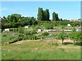
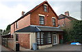
Allotments
Allotments at the foot of Green Hill, bask in the June sunshine.
Image: © Donnylad
Taken: 1 Jun 2007
0.06 miles
2
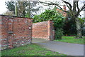
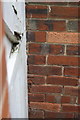
Brick boundary wall of #81A Barrowby Road
There is an OS benchmark Image on the corner of the wall on the far side of the entrance drive, behind a bush
Image: © Roger Templeman
Taken: 7 Apr 2016
0.07 miles
3
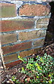
Benchmark on wall angle outside #81A Barrowby Road
Ordnance Survey cut mark benchmark described on the Bench Mark Database at http://www.bench-marks.org.uk/bm74713
Image: © Roger Templeman
Taken: 7 Apr 2016
0.07 miles
4
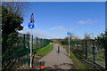
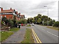
Foot and cycle path north of Barrowby Road, Grantham
The path runs from Barrowby Road round the perimeter of the new Poplar Farm urban extension. Here it passes the Barrowby Road Allotments.
Image: © Tim Heaton
Taken: 9 Mar 2021
0.10 miles
5

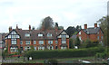
Green Hill Road, Grantham
A late Victorian terrace built 1896.
Image: © Anthony Vosper
Taken: 18 Feb 2014
0.12 miles
7
#115 Barrowby Road
There is an OS benchmark Image on the right hand side of the house, near its front corner
Image: © Roger Templeman
Taken: 7 Apr 2016
0.14 miles
8
Benchmark on #115 Barrowby Road
Ordnance Survey cut mark benchmark, partly hidden by gatepost, described on the Bench Mark Database at http://www.bench-marks.org.uk/bm74714
Image: © Roger Templeman
Taken: 7 Apr 2016
0.14 miles
10
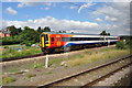
East Midlands Service nearing Grantham
The train runs from Liverpool to Norwich, it was the service I was using from Norwich to Peterborough before changing to the faster East Coast Mainline to Doncaster.
Image: © Ashley Dace
Taken: 11 Aug 2010
0.15 miles