IMAGES TAKEN NEAR TO
Richmond Drive, GRANTHAM, NG31 8UD
Introduction
This page details the photographs taken nearby to Richmond Drive, NG31 8UD by members of the Geograph project.
The Geograph project started in 2005 with the aim of publishing, organising and preserving representative images for every square kilometre of Great Britain, Ireland and the Isle of Man.

There are currently over 7.5m images from over14,400 individuals and you can help contribute to the project by visiting https://www.geograph.org.uk
Image Map
Images are licensed for reuse under creativecommons.org/licenses/by-sa/2.0
Notes
- Clicking on the map will re-center to the selected point.
- The higher the marker number, the further away the image location is from the centre of the postcode.
Image Listing (14 Images Found)
Images are licensed for reuse under creativecommons.org/licenses/by-sa/2.0
Image
Details
Distance
1
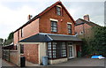
#115 Barrowby Road
There is an OS benchmark Image on the right hand side of the house, near its front corner
Image: © Roger Templeman
Taken: 7 Apr 2016
0.09 miles
2
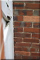
Benchmark on #115 Barrowby Road
Ordnance Survey cut mark benchmark, partly hidden by gatepost, described on the Bench Mark Database at http://www.bench-marks.org.uk/bm74714
Image: © Roger Templeman
Taken: 7 Apr 2016
0.09 miles
3
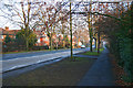
Green Hill, Grantham
The street is called Barrowby Road and is the A52 to Nottingham. Looking towards Grantham town centre,
Image: © Kate Jewell
Taken: 28 Jan 2006
0.10 miles
4
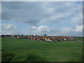
Housing estate on leaving Grantham
As viewed from the train bound for Nottingham.
Image: © Richard Hoare
Taken: 7 May 2010
0.11 miles
5
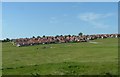
Greenfield Incursion
Property development gradually encroaches across the farmland near to Grantham.
Image: © Donnylad
Taken: 1 Jun 2007
0.11 miles
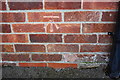
6
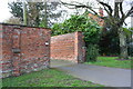
Brick boundary wall of #81A Barrowby Road
There is an OS benchmark Image on the corner of the wall on the far side of the entrance drive, behind a bush
Image: © Roger Templeman
Taken: 7 Apr 2016
0.15 miles
7
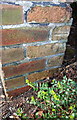
Benchmark on wall angle outside #81A Barrowby Road
Ordnance Survey cut mark benchmark described on the Bench Mark Database at http://www.bench-marks.org.uk/bm74713
Image: © Roger Templeman
Taken: 7 Apr 2016
0.16 miles
8
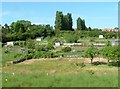
Allotments
Allotments at the foot of Green Hill, bask in the June sunshine.
Image: © Donnylad
Taken: 1 Jun 2007
0.16 miles
9
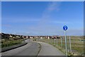
Lauriston Road, Grantham
Looking towards part of the Poplar Farm 'urban extension'. The development anticipates almost 2,000 dwellings with school and other community facilities.
Image: © Tim Heaton
Taken: 9 Mar 2021
0.17 miles
10
Benchmark on #145 Barrowby Road
Ordnance Survey cut mark benchmark described on the Bench Mark Database at http://www.bench-marks.org.uk/bm74715
Image: © Roger Templeman
Taken: 7 Apr 2016
0.19 miles