IMAGES TAKEN NEAR TO
Bristol Close, GRANTHAM, NG31 8SL
Introduction
This page details the photographs taken nearby to Bristol Close, NG31 8SL by members of the Geograph project.
The Geograph project started in 2005 with the aim of publishing, organising and preserving representative images for every square kilometre of Great Britain, Ireland and the Isle of Man.

There are currently over 7.5m images from over14,400 individuals and you can help contribute to the project by visiting https://www.geograph.org.uk
Image Map
Images are licensed for reuse under creativecommons.org/licenses/by-sa/2.0
Notes
- Clicking on the map will re-center to the selected point.
- The higher the marker number, the further away the image location is from the centre of the postcode.
Image Listing (3 Images Found)
Images are licensed for reuse under creativecommons.org/licenses/by-sa/2.0
Image
Details
Distance
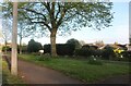
1
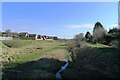
Barrowby Stream balancing pond (currently dry)
An area of about 5 acres in the western suburbs of Grantham. Constructed to hold back flood water from flowing towards the River Witham in the centre of Grantham.
Image: © Tim Heaton
Taken: 9 Mar 2021
0.24 miles
2
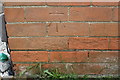
Benchmark on #203 Dysart Road
Ordnance Survey cut mark benchmark described on the Bench Mark Database at www.bench-marks.org.uk/bm107332
Image: © Roger Templeman
Taken: 7 May 2019
0.25 miles