IMAGES TAKEN NEAR TO
Barrowby Road, GRANTHAM, NG31 8NT
Introduction
This page details the photographs taken nearby to Barrowby Road, NG31 8NT by members of the Geograph project.
The Geograph project started in 2005 with the aim of publishing, organising and preserving representative images for every square kilometre of Great Britain, Ireland and the Isle of Man.

There are currently over 7.5m images from over14,400 individuals and you can help contribute to the project by visiting https://www.geograph.org.uk
Image Map
Images are licensed for reuse under creativecommons.org/licenses/by-sa/2.0
Notes
- Clicking on the map will re-center to the selected point.
- The higher the marker number, the further away the image location is from the centre of the postcode.
Image Listing (9 Images Found)
Images are licensed for reuse under creativecommons.org/licenses/by-sa/2.0
Image
Details
Distance
3
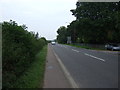
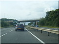
Barrowby Road (A52)
Heading east towards Grantham.
Image: © JThomas
Taken: 27 Jul 2013
0.10 miles
4
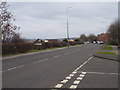
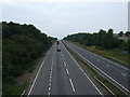
Welcome to Grantham
What once was the outskirts of the town is slowly being in filled with new housing.
Image: © Anthony Vosper
Taken: 18 Feb 2014
0.22 miles
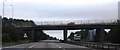
6
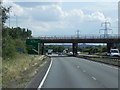
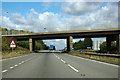
Bridge Carrying the A52 over the A1 at Barrowby
Image: © David Dixon
Taken: 4 Aug 2014
0.23 miles