IMAGES TAKEN NEAR TO
Gonerby Road, GRANTHAM, NG31 8HX
Introduction
This page details the photographs taken nearby to Gonerby Road, NG31 8HX by members of the Geograph project.
The Geograph project started in 2005 with the aim of publishing, organising and preserving representative images for every square kilometre of Great Britain, Ireland and the Isle of Man.

There are currently over 7.5m images from over14,400 individuals and you can help contribute to the project by visiting https://www.geograph.org.uk
Image Map
Images are licensed for reuse under creativecommons.org/licenses/by-sa/2.0
Notes
- Clicking on the map will re-center to the selected point.
- The higher the marker number, the further away the image location is from the centre of the postcode.
Image Listing (19 Images Found)
Images are licensed for reuse under creativecommons.org/licenses/by-sa/2.0
Image
Details
Distance
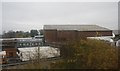
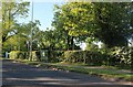
3
Arnoldfield sports ground
Off the Grantham to Gonerby road,catering for a number of sports including tennis and bowling.
Image: © Anthony Vosper
Taken: 24 Feb 2011
0.09 miles
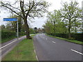
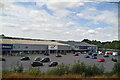
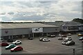
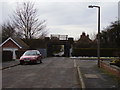
4
Gonerby Hill Foot, Grantham
Looking towards Grantham Tennis Club
Image: © David Howard
Taken: 7 May 2023
0.09 miles
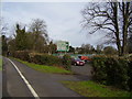
5
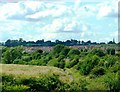
Below Great Gonerby
Great Gonerby tops the hill to the Northwest of Grantham, while in the valley the vegetation to the side of the railway embankment basks in the afternoon sunshine.
Image: © Donnylad
Taken: 7 Jul 2007
0.14 miles
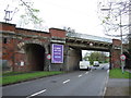
9
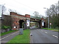
Railway bridge over The Maltings
At Gonerby Hill Foot.
Image: © Anthony Vosper
Taken: 14 Feb 2012
0.21 miles