IMAGES TAKEN NEAR TO
Prospect Place, GRANTHAM, NG31 8FA
Introduction
This page details the photographs taken nearby to Prospect Place, NG31 8FA by members of the Geograph project.
The Geograph project started in 2005 with the aim of publishing, organising and preserving representative images for every square kilometre of Great Britain, Ireland and the Isle of Man.

There are currently over 7.5m images from over14,400 individuals and you can help contribute to the project by visiting https://www.geograph.org.uk
Image Map
Images are licensed for reuse under creativecommons.org/licenses/by-sa/2.0
Notes
- Clicking on the map will re-center to the selected point.
- The higher the marker number, the further away the image location is from the centre of the postcode.
Image Listing (441 Images Found)
Images are licensed for reuse under creativecommons.org/licenses/by-sa/2.0
Image
Details
Distance
1
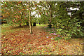
The old burial ground
A rare view of the old burial ground behind houses on Manthorpe Road. When St.Wulfrum's churchyard was full in 1812, burials took place here until the new municipal cemetery opened in 1857, long-closed, it is open for 2½ hours a year.
Image: © Richard Croft
Taken: 15 Sep 2013
0.02 miles
2
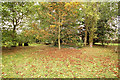
The old burial ground
A rare view of the old burial ground behind houses on Manthorpe Road. When St.Wulfrum's churchyard was full in 1812, burials took place here until the new municipal cemetery opened in 1857, long-closed, it is open for 2½ hours a year.
Image: © Richard Croft
Taken: 15 Sep 2013
0.02 miles
3
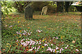
The old burial ground
A rare view of the old burial ground behind houses on Manthorpe Road. When St.Wulfrum's churchyard was full in 1812, burials took place here until the new municipal cemetery opened in 1857, long-closed, it is open for 2½ hours a year.
Image: © Richard Croft
Taken: 15 Sep 2013
0.03 miles
4
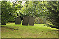
The old burial ground
Slate headstones in the old burial ground behind houses on Manthorpe Road. When St.Wulfrum's churchyard was full in 1812, burials took place here until the new municipal cemetery opened in 1857, long-closed, it is open for 2½ hours a year.
Image: © Richard Croft
Taken: 15 Sep 2013
0.03 miles
5
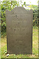
Azubah Croft
Headstone for Azubah Croft in the old burial ground behind houses on Manthorpe Road. When St.Wulfrum's churchyard was full in 1812, burials took place here until the new municipal cemetery opened in 1857, long-closed, it is open for 2½ hours a year.
As her headstone says, she died May 15th 1817 aged 29 years
She was baptised 30th January 1788 at St.Martins in Lincoln, daughter of Joseph and Mary Croft. She died unmarried and was buried here on 19th May 1817.
Image: © Richard Croft
Taken: 15 Sep 2013
0.03 miles
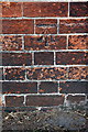
6
Benchmark on wall of #30 Gladstone Terrace
Ordnance Survey rivet benchmark described on the Bench Mark Database at http://www.bench-marks.org.uk/bm56770
Image: © Roger Templeman
Taken: 19 Apr 2014
0.04 miles
7
#30 Gladstone Terrace
There is an OS benchmark Image on top of the middle of the wall in front of the house
Image: © Roger Templeman
Taken: 7 Apr 2016
0.04 miles
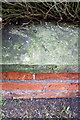
8
Benchmark on Manthorpe Road wall opposite Slate Mill Place
Ordnance Survey cut mark benchmark described on the Bench Mark Database at http://www.bench-marks.org.uk/bm74711
Image: © Roger Templeman
Taken: 7 Apr 2016
0.05 miles
9
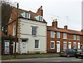
Bow House, 43, Manthorpe Road, Grantham
Late 18th century Georgian house with first floor bow window, from which it presumably takes its name. Listed Grade II.
Image: © Alan Murray-Rust
Taken: 15 Feb 2017
0.05 miles
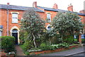
10

Manthorpe Road
Cottages on Manthorpe Road
Image: © Richard Croft
Taken: 13 Dec 2007
0.05 miles