IMAGES TAKEN NEAR TO
Longcliffe Road, GRANTHAM, NG31 8DU
Introduction
This page details the photographs taken nearby to Longcliffe Road, NG31 8DU by members of the Geograph project.
The Geograph project started in 2005 with the aim of publishing, organising and preserving representative images for every square kilometre of Great Britain, Ireland and the Isle of Man.

There are currently over 7.5m images from over14,400 individuals and you can help contribute to the project by visiting https://www.geograph.org.uk
Image Map
Images are licensed for reuse under creativecommons.org/licenses/by-sa/2.0
Notes
- Clicking on the map will re-center to the selected point.
- The higher the marker number, the further away the image location is from the centre of the postcode.
Image Listing (36 Images Found)
Images are licensed for reuse under creativecommons.org/licenses/by-sa/2.0
Image
Details
Distance
1
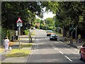
Pedestrian Controlled Traffic Lights on Manthorpe Road
Image: © David Dixon
Taken: 5 Aug 2014
0.09 miles
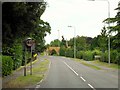
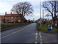
3
A607 heading into Grantham
Manthorpe Road, the A670, descending towards the town centre.
Image: © Trevor Littlewood
Taken: 10 Nov 2022
0.10 miles
4
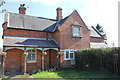
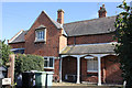
Kettle Cottage, 37 Low Road, Manthorpe
Mid 19th century Grade II Listed estate cottage provided for workers on the Belton estate by the Brownlow family of Belton House. Despite having a Low Road address the cottage is on Manthorpe Road and the road layout appears not to have changed as far back as the 1814 map although the junction may have moved northwards a little by reducing in size.
Image: © Jo and Steve Turner
Taken: 24 Mar 2017
0.12 miles
5
Holly Cottage, 38 Low Road, Manthorpe
Mid 19th century Grade II Listed estate cottage provided for workers on the Belton estate by the Brownlow family of Belton House. Despite having a Low Road address the cottage is on Manthorpe Road and the road layout appears not to have changed as far back as the 1814 map although the junction may have moved northwards a little by reducing in size.
Image: © Jo and Steve Turner
Taken: 24 Mar 2017
0.12 miles
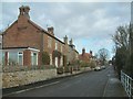
6
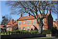
High Road 1 and 2 South View, Manthorpe
Grade II Listed estate farmhouse of 1800, remodelled in 1851 by the Brownlow family of Belton House.
Image: © Jo and Steve Turner
Taken: 24 Mar 2017
0.13 miles
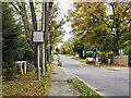
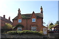
7
High Road, Manthorpe
Low road to the right. A grade II Listed farmhouse to the left and St john's church in the centre.
Image: © Anthony Vosper
Taken: 13 Feb 2012
0.13 miles
8
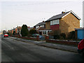
Redcliffe Road
The first house on the right, number 18, is where I lived in 1976 until I left the RAF and moved to Nottingham.
Image: © Peter Langsdale
Taken: Unknown
0.14 miles
10
4 High Road, Manthorpe
Previously 3 and 4 High Road a pair of estate cottages provided for workers on the Belton estate by the Brownlow family of Belton House. Grade II Listed mid 19th century with late 20th century alterations.
Image: © Jo and Steve Turner
Taken: 24 Mar 2017
0.14 miles