IMAGES TAKEN NEAR TO
Farndale Crescent, GRANTHAM, NG31 8DR
Introduction
This page details the photographs taken nearby to Farndale Crescent, NG31 8DR by members of the Geograph project.
The Geograph project started in 2005 with the aim of publishing, organising and preserving representative images for every square kilometre of Great Britain, Ireland and the Isle of Man.

There are currently over 7.5m images from over14,400 individuals and you can help contribute to the project by visiting https://www.geograph.org.uk
Image Map (Loading...)


Getting Data...Please wait
Leaflet Map data © OpenStreetMap
Images are licensed for reuse under creativecommons.org/licenses/by-sa/2.0
Notes
- Clicking on the map will re-center to the selected point.
- The higher the marker number, the further away the image location is from the centre of the postcode.
Image Listing (5 Images Found)
Images are licensed for reuse under creativecommons.org/licenses/by-sa/2.0
Image
Details
Distance
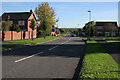
2
1970s housing, Grantham
There are lots of 1970s housing estates in Grantham. This shows the junction of Teesdale Road with Dale Road to the north of the hospital off Manthorpe Road.
Image: © Kate Jewell
Taken: 29 Oct 2006
0.20 miles
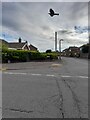
4

Running Furrows Gate
A John Mills 'Fossil Tree' milepost by Running Furrows Gate cycle route
Image: © Richard Croft
Taken: 6 May 2014
0.23 miles
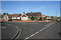
5
Ravendale Close, Grantham
1980s housing
Image: © Kate Jewell
Taken: 29 Oct 2006
0.25 miles