IMAGES TAKEN NEAR TO
New Street, GRANTHAM, NG31 8BD
Introduction
This page details the photographs taken nearby to New Street, NG31 8BD by members of the Geograph project.
The Geograph project started in 2005 with the aim of publishing, organising and preserving representative images for every square kilometre of Great Britain, Ireland and the Isle of Man.

There are currently over 7.5m images from over14,400 individuals and you can help contribute to the project by visiting https://www.geograph.org.uk
Image Map
Images are licensed for reuse under creativecommons.org/licenses/by-sa/2.0
Notes
- Clicking on the map will re-center to the selected point.
- The higher the marker number, the further away the image location is from the centre of the postcode.
Image Listing (502 Images Found)
Images are licensed for reuse under creativecommons.org/licenses/by-sa/2.0
Image
Details
Distance
1
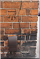
Benchmark on #17 Chambers Street
Ordnance Survey cut mark benchmark described on the Bench Mark Database at http://www.bench-marks.org.uk/bm56808
Image: © Roger Templeman
Taken: 19 Apr 2014
0.01 miles
2
Care home at junction of Albion Street and New Street
There is possibly an OS benchmark Image on the inside face of the wall end on the left hand side of the entrance to this former school
Image: © Roger Templeman
Taken: 19 Apr 2014
0.02 miles
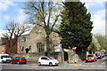
3
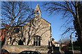
Former infants school, New Street, Grantham
Dated 1863. Now converted to a residential care home.
Image: © Alan Murray-Rust
Taken: 9 Feb 2017
0.02 miles
4
Junction of Chambers Street and Albion Road
There is an OS benchmark Image on the corner of the near house on the Chambers Street face above a Virgin Media connection box
Image: © Roger Templeman
Taken: 19 Apr 2014
0.02 miles
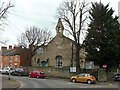
5
Belvoir House Care Home
Care home, formerly Little Gonerby Church of England Infant School with a datestone of 1863
Image: © Richard Croft
Taken: 2 Feb 2007
0.02 miles
6
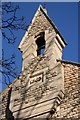
Belvoir House belcote
Belcote and datestone on Belvoir House Care Home http://www.geograph.org.uk/photo/333714
Image: © Richard Croft
Taken: 2 Feb 2007
0.03 miles
7
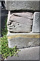
Remains of a benchmark on gatepier of Belvoir House Care Home?
Ordnance Survey cut mark benchmark described on the Bench Mark Database at http://www.bench-marks.org.uk/bm57028
Image: © Roger Templeman
Taken: 19 Apr 2014
0.03 miles
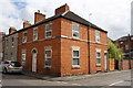
8
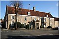
Miss Farish Almshouses
Number 10 Brownlow Street, known as Miss Farish Almshouses, has a datestone of 1653
Image: © Richard Croft
Taken: 2 Feb 2007
0.04 miles
9
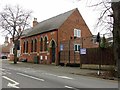
Scout Hall, Broad Street
Built in 1886 as a Primitive Methodist chapel.
Image: © Alan Murray-Rust
Taken: 9 Feb 2017
0.04 miles
10
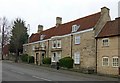
2 Brownlow Street, Grantham
17th century stone house, built 1653 http://www.geograph.org.uk/photo/5281631 by Thomas Hurst, who founded the almshouses on Church Trees http://www.geograph.org.uk/photo/5280725 . Listed Grade II.
Image: © Alan Murray-Rust
Taken: 9 Feb 2017
0.05 miles