IMAGES TAKEN NEAR TO
Turnpike Close, GRANTHAM, NG31 7XU
Introduction
This page details the photographs taken nearby to Turnpike Close, NG31 7XU by members of the Geograph project.
The Geograph project started in 2005 with the aim of publishing, organising and preserving representative images for every square kilometre of Great Britain, Ireland and the Isle of Man.

There are currently over 7.5m images from over14,400 individuals and you can help contribute to the project by visiting https://www.geograph.org.uk
Image Map
Images are licensed for reuse under creativecommons.org/licenses/by-sa/2.0
Notes
- Clicking on the map will re-center to the selected point.
- The higher the marker number, the further away the image location is from the centre of the postcode.
Image Listing (47 Images Found)
Images are licensed for reuse under creativecommons.org/licenses/by-sa/2.0
Image
Details
Distance
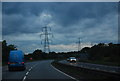
2
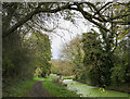
The Grantham Canal
Seen here approaching the town with the A1 just a couple of hundred metres ahead.
Image: © Jonathan Clitheroe
Taken: 2 Mar 2024
0.12 miles
3

Grantham Police Station
Divisional headquarters for the Lincolnshire Police. Built in 2008 for £9 million http://news.bbc.co.uk/1/hi/england/lincolnshire/7339130.stm
Image: © Tim Heaton
Taken: 9 Mar 2021
0.12 miles
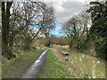
4
The eastern end of the Grantham Canal
This is the eastern most end of the current navigable section of the Grantham Canal. Up ahead, the embankment of the A1 dual carriageway blocks the canal.
Image: © Mat Fascione
Taken: 17 May 2014
0.12 miles
5
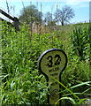
Milepost next to the Grantham Canal
This milepost is at the eastern most end of the current navigable section of the Grantham Canal, next to the embankment of the A1 dual carriageway which blocks the canal.
Image: © Mat Fascione
Taken: 17 May 2014
0.13 miles
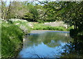
6
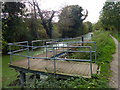
Grantham Canal meeting the A1 bypass
The Grantham Canal once entered the town itself but by 1962 the A1 road had been completely rerouted to bypass the town on its western side. That work severed the canal short of its terminus and now has the main length of the waterway ending at the location at the centre of the image just beyond a pontoon on which a resting walker can be seen. There's a break in the pontoon now (November 2022); Mat Fascione's image from 2014 shows it intact - https://www.geograph.org.uk/photo/5253730 .
Image: © Trevor Littlewood
Taken: 8 Nov 2022
0.13 miles
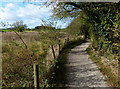
7
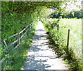
Path on the edge of Grantham
This path runs between the Grantham Canal and the A607 Harlaxton Road.
Image: © Mat Fascione
Taken: 17 May 2014
0.13 miles
8
Pontoon along the Grantham Canal
At the eastern most end of the current navigable section of the Grantham Canal.
Image: © Mat Fascione
Taken: 29 Oct 2017
0.15 miles
9
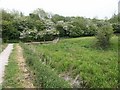
Grantham Canal obstacle
Looking NE towards the embankment of the A1 which totally blocks the canal route about 2km short of Grantham centre. A healthy looking crop of reeds fills this part of the canal channel, still in water.
Image: © Martin Wilson
Taken: 21 May 2005
0.15 miles
10
Path to the Grantham Canal
This path runs between the A607 Harlaxton Road and the Grantham Canal.
Image: © Mat Fascione
Taken: 29 Oct 2017
0.16 miles