IMAGES TAKEN NEAR TO
Muston Road, GRANTHAM, NG31 7XE
Introduction
This page details the photographs taken nearby to Muston Road, NG31 7XE by members of the Geograph project.
The Geograph project started in 2005 with the aim of publishing, organising and preserving representative images for every square kilometre of Great Britain, Ireland and the Isle of Man.

There are currently over 7.5m images from over14,400 individuals and you can help contribute to the project by visiting https://www.geograph.org.uk
Image Map
Images are licensed for reuse under creativecommons.org/licenses/by-sa/2.0
Notes
- Clicking on the map will re-center to the selected point.
- The higher the marker number, the further away the image location is from the centre of the postcode.
Image Listing (29 Images Found)
Images are licensed for reuse under creativecommons.org/licenses/by-sa/2.0
Image
Details
Distance
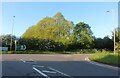
2
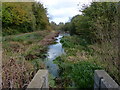
Grantham Canal next to the A1 slip road
Image: © Mat Fascione
Taken: 29 Oct 2017
0.14 miles
5
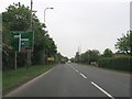
Harlaxton Road, Grantham
At the A1 sliproad
Image: © David Howard
Taken: 7 May 2023
0.17 miles
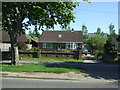
6
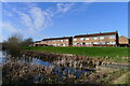
Houses on Hickling Close, overlooking the Grantham Canal
Image: © Tim Heaton
Taken: 9 Mar 2021
0.17 miles
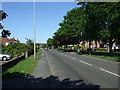
7
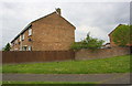
Wall, fence and housing on south side of Trent Road
There is an OS benchmark Image on the brick wall near its left hand corner
Image: © phil Richards
Taken: 7 May 2019
0.18 miles
8
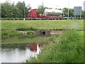
Grantham Canal roundabout
Still with plenty of water in its channel, the canal is culverted under a new roundabout linking to an A1 slip-road.
Image: © Martin Wilson
Taken: 21 May 2005
0.18 miles
9
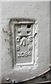
Benchmark on #307 Harlaxton Road
Ordnance Survey flush bracket (serial number 2084) described on the Bench Mark Database at www.bench-marks.org.uk/bm1900
Image: © phil Richards
Taken: 7 May 2019
0.19 miles
10
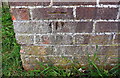
Benchmark on brick wall on south side of Trent Road
Ordnance Survey cut mark benchmark described on the Bench Mark Database at www.bench-marks.org.uk/bm107397
Image: © phil Richards
Taken: 7 May 2019
0.19 miles