IMAGES TAKEN NEAR TO
Waterworks Lane, GRANTHAM, NG31 7UL
Introduction
This page details the photographs taken nearby to Waterworks Lane, NG31 7UL by members of the Geograph project.
The Geograph project started in 2005 with the aim of publishing, organising and preserving representative images for every square kilometre of Great Britain, Ireland and the Isle of Man.

There are currently over 7.5m images from over14,400 individuals and you can help contribute to the project by visiting https://www.geograph.org.uk
Image Map
Images are licensed for reuse under creativecommons.org/licenses/by-sa/2.0
Notes
- Clicking on the map will re-center to the selected point.
- The higher the marker number, the further away the image location is from the centre of the postcode.
Image Listing (6 Images Found)
Images are licensed for reuse under creativecommons.org/licenses/by-sa/2.0
Image
Details
Distance
1
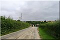
Entrance lane to Grantham Water Works at Salter's Ford
Salter's Ford crossed the River Witham amongst the trees behind the water works. It was the site of a Roman settlement (possibly Causennae), located where the Roman 'Salt Way' road (which would have run along, or close to this lane) crossed the river before meeting Ermine street just over a mile to the east https://www.lincstothepast.com/Romano-British-Settlement--Saltersford/226373.record?pt=S
Image: © Tim Heaton
Taken: 31 Aug 2021
0.02 miles
2
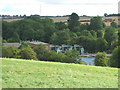
Saltersford Water Treatment Works near Grantham
At SK 926 332, the water treatment tanks and reservoir are just across the River Witham which is just out of sight at the bottom of the slope.
Image: © Kate Jewell
Taken: 25 Aug 2005
0.03 miles
3
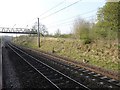
View from a Doncaster-Peterborough train - pipeline to Saltersford water treatment works
Image: © Nigel Thompson
Taken: 17 Apr 2019
0.16 miles
5
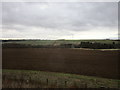
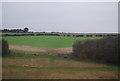
The Witham valley
Looking from Spittlegate Hill across to Somerby Hill.
Image: © Jonathan Thacker
Taken: 9 Jan 2020
0.21 miles
6
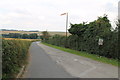
Track to Saltersford Water Treatment Works
Image: © J.Hannan-Briggs
Taken: 12 Aug 2012
0.25 miles