IMAGES TAKEN NEAR TO
Gorse Lane, GRANTHAM, NG31 7UF
Introduction
This page details the photographs taken nearby to Gorse Lane, NG31 7UF by members of the Geograph project.
The Geograph project started in 2005 with the aim of publishing, organising and preserving representative images for every square kilometre of Great Britain, Ireland and the Isle of Man.

There are currently over 7.5m images from over14,400 individuals and you can help contribute to the project by visiting https://www.geograph.org.uk
Image Map
Images are licensed for reuse under creativecommons.org/licenses/by-sa/2.0
Notes
- Clicking on the map will re-center to the selected point.
- The higher the marker number, the further away the image location is from the centre of the postcode.
Image Listing (10 Images Found)
Images are licensed for reuse under creativecommons.org/licenses/by-sa/2.0
Image
Details
Distance

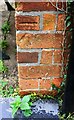
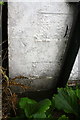
3
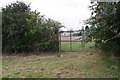
Gateway on SE side of Gorse Lane
Ordnance Survey records indicate that a benchmark levelled at 111.579m above Newlyn Datum was on a concrete gatepost here.
Image: © phil Richards
Taken: 9 Sep 2019
0.10 miles
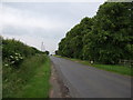
5
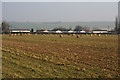
Farmland near Grantham
This farmland is off Gorse Lane. Grantham Caravans, a caravan sales company, also runs a static site which can be seen in the photograph.
Image: © Kate Jewell
Taken: 28 Jan 2006
0.16 miles
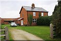
6
Benchmark on house on NW side of Gorse Lane
Ordnance Survey cut mark benchmark described on the Bench Mark Database at www.bench-marks.org.uk/bm111490
Image: © phil Richards
Taken: 9 Sep 2019
0.16 miles
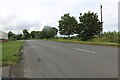
7
Semi-detached houses on the NW side of Gorse Lane
There is an OS benchmark Image on the front of the left hand house at its front corner, left of the black downpipe
Image: © phil Richards
Taken: 9 Sep 2019
0.16 miles
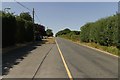
8
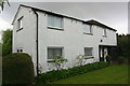
'White House', Gorse Lane
There is an Ordnance Survey benchmark Image on the near corner of the house, left of the black downpipe
Image: © phil Richards
Taken: 9 Sep 2019
0.23 miles
9
Benchmark on the White House
Ordnance Survey cut mark benchmark described on the Bench Mark Database at www.bench-marks.org.uk/bm111489
Image: © phil Richards
Taken: 9 Sep 2019
0.23 miles